IMAGES TAKEN NEAR TO
Greville Road, WARWICK, CV34 5PJ
Introduction
This page details the photographs taken nearby to Greville Road, CV34 5PJ by members of the Geograph project.
The Geograph project started in 2005 with the aim of publishing, organising and preserving representative images for every square kilometre of Great Britain, Ireland and the Isle of Man.

There are currently over 7.5m images from over14,400 individuals and you can help contribute to the project by visiting https://www.geograph.org.uk
Image Map
Images are licensed for reuse under creativecommons.org/licenses/by-sa/2.0
Notes
- Clicking on the map will re-center to the selected point.
- The higher the marker number, the further away the image location is from the centre of the postcode.
Image Listing (249 Images Found)
Images are licensed for reuse under creativecommons.org/licenses/by-sa/2.0
Image
Details
Distance
1
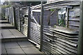
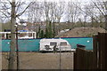
Contractor's compound, 'The Waterfront', Warwick
Image: © Robin Stott
Taken: 15 Mar 2009
0.05 miles
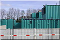
2
Contractor's compound, 'The Waterfront', Warwick
The mini-skips are colour-coded for recycling surplus materials.
Image: © Robin Stott
Taken: 19 Mar 2009
0.05 miles
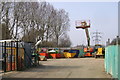
3
The other end of The Waterfront, Warwick
The more publicly visible face of the development can be seen in David Stowell's photo at Image
To amplify, the incomplete concrete structures are the 'undercrofts' or ground floors of FOGs - flats over garages - yet to be built.
The building contractor uses them as covered storage for materials. Construction may proceed later in 2009.
I learnt this from the site manager who reproved me for not seeking permission to photograph the site compound: Image
Image: © Robin Stott
Taken: 20 Mar 2009
0.05 miles
4
Layers of development, Warwick and Leamington
From the steps that descend from Greville Road, Warwick Image there is a view across the Waterfront contractor's vacant car park.
Between the incomplete FOGs Image and a pile of crushed concrete is a glimpse of the development on the quarry site across the Avon and upstream from Rock Mill Image Above and beyond that is housing off Riversleigh Road in Milverton.
Image: © Robin Stott
Taken: 30 Mar 2009
0.05 miles
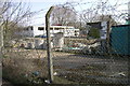
5
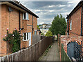
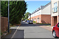
Steps off Greville Road, Warwick
They lead down to a track, the continuation of Portobello Way, that gives access to the Percy Estate allotments, the rear of Greville Road properties, and an electricity pylon. In the background is one of the blocks of flats on the Waterfront development on the site of the Potterton's boiler factory. Greville was a family name of the Earls of Warwick.
Image: © Robin Stott
Taken: 2 Jun 2022
0.06 miles
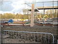
6
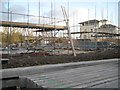
New foundations and scaffolding, Riverfront site, Emscote, east Warwick
Viewed from the public track to the allotments, the terminal tower and properties.
Image: © Robin Stott
Taken: 3 Feb 2016
0.06 miles
7
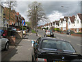
Off-road parking ends here, Greville Road
A grass verge was sacrificed to avoid hold-ups by parked cars on busy Greville Road. The turning on the left is Beauchamp Road. Both Greville and Beauchamp (pron. beecham) were both family names of the Earls of Warwick.
Image: © Robin Stott
Taken: 22 Apr 2012
0.06 miles
8
North on Portobello Way, east Warwick
The affordable homes section of the incomplete Waterfront development. The road becomes a track leading to Pottertons allotments. On the left the rear of Greville Road properties; Leyland Cypress getting going.
Image: © Robin Stott
Taken: 26 Aug 2015
0.07 miles
9
Construction of flats has restarted on the Waterfront site, Portobello, Warwick
The flats are square in plan, 3-5 storey blocks, similar to those built a few years ago, before the financial crisis 2008-9. Houses in the distance are in Leamington, across the River Avon. The view is from the unmade track to the allotments, an electricity pylon and private properties.
Image: © Robin Stott
Taken: 3 Feb 2016
0.07 miles