IMAGES TAKEN NEAR TO
Farmside, COVENTRY, CV3 3GF
Introduction
This page details the photographs taken nearby to Farmside, CV3 3GF by members of the Geograph project.
The Geograph project started in 2005 with the aim of publishing, organising and preserving representative images for every square kilometre of Great Britain, Ireland and the Isle of Man.

There are currently over 7.5m images from over14,400 individuals and you can help contribute to the project by visiting https://www.geograph.org.uk
Image Map
Images are licensed for reuse under creativecommons.org/licenses/by-sa/2.0
Notes
- Clicking on the map will re-center to the selected point.
- The higher the marker number, the further away the image location is from the centre of the postcode.
Image Listing (20 Images Found)
Images are licensed for reuse under creativecommons.org/licenses/by-sa/2.0
Image
Details
Distance
1
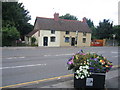
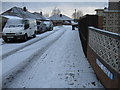
Willenhall, The Bear
Modern pub at the corner of St James Lane & Wroxall Avenue. Internally, bar to left, drinking area to right, games room (pool) to rear; TV, music (very loud), games machines. No cask ale available at my visit, despite the sign outside; appears to be a male preserve.
Image: © Mike Faherty
Taken: 21 Nov 2010
0.08 miles
2
Willenhall, Catholic church
St. Anne's R.C. Church, on the corner of St. James Lane and Dunsmore Avenue. http://www.birminghamdiocese.org.uk/parish_directory_detail.asp?parish=166
Image: © Mike Faherty
Taken: 21 Nov 2010
0.10 miles
3
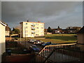
Blocks of flats being fitted with external insulation, Wroxall Drive, Willenhall
Part of a large programme of cladding undertaken by social housing providers in Coventry at this time.
Image: © A J Paxton
Taken: 30 Apr 2014
0.10 miles
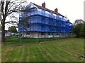
4
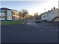
Whitefriars Housing office for Willenhall tenants, St James' Lane, southeast Coventry
There is a small depot behind for the Homeworks housing repairs team. The scrubby woodland at the back has developed in recent years. From the 1930s to the 1970s the land is shown on old maps as a market garden and later as a nursery. This office may be the building that appears around 1980. A view from the west is Image
Whitefriars Housing is a registered social landlord, Coventry's largest. It is part of the WM Housing Group: https://www.wmhousing.co.uk/wp-content/uploads/2016/11/documents-corporate-groupstructure-group-structure-chart.pdf
Image: © Robin Stott
Taken: 5 Oct 2016
0.10 miles
5
East end of Yarningale Road seen from Middle Ride, Willenhall, southeast Coventry
The low sun catches the leaves on a few shoots trailing from a much-pruned weeping willow.
Image: © Robin Stott
Taken: 5 Jan 2017
0.12 miles
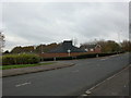
6
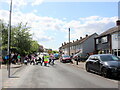
School Crossing on St James' Lane
It is going home time and the children are pouring out of Willenhall Community Primary School on St James' Lane.
Image: © Nigel Mykura
Taken: 15 May 2023
0.15 miles
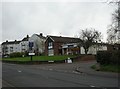
7
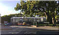
Old Houses, St James lane
A few of the older buildings in this area largely dominated by post-war development.
Image: © David Stowell
Taken: 6 Aug 2005
0.17 miles
9
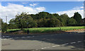
Open land at the corner of Stretton Avenue and Dunsmore Avenue, Willenhall, Coventry
Dunsmore Avenue runs across the picture, climbing left to right. The dense growth of scrub is on a strip of land running back from St James' Lane. A map of 1938 shows a small building on it, identified in 1947 as greenhouses and the land as 'Market Garden'. From the 1950s to the 1970s it is shown as 'Nursery'; a building appears at the front of the site. On a map of 1982 the site is unidentified and by 1992 carries tree symbols. Bollards at the edge of the trees, right, suggest public access.
Image: © Robin Stott
Taken: 5 Oct 2016
0.18 miles