IMAGES TAKEN NEAR TO
Dogberry Close, COVENTRY, CV3 3AQ
Introduction
This page details the photographs taken nearby to Dogberry Close, CV3 3AQ by members of the Geograph project.
The Geograph project started in 2005 with the aim of publishing, organising and preserving representative images for every square kilometre of Great Britain, Ireland and the Isle of Man.

There are currently over 7.5m images from over14,400 individuals and you can help contribute to the project by visiting https://www.geograph.org.uk
Image Map
Images are licensed for reuse under creativecommons.org/licenses/by-sa/2.0
Notes
- Clicking on the map will re-center to the selected point.
- The higher the marker number, the further away the image location is from the centre of the postcode.
Image Listing (41 Images Found)
Images are licensed for reuse under creativecommons.org/licenses/by-sa/2.0
Image
Details
Distance
1
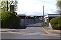
Gates to St Anne's Catholic Primary School, Chace Avenue, Willenhall, southeast Coventry
Image: © Robin Stott
Taken: 30 Apr 2016
0.09 miles
2
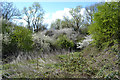
Blackthorn and hawthorn by the River Sowe south of the Alan Higgs Centre, Coventry
Hawthorn (and willows) coming into new leaf. Blackthorn – clouds of white flowers dusting black thickets everywhere – a riot, a joy. Bleached stems in the foreground are probably last year's nettles; the new growth is showing. The river, hardly visible, takes a sharp turn south here.
Image: © Robin Stott
Taken: 27 Apr 2016
0.10 miles
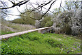
3
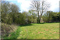
An inviting gap
Rough grass to the south of a football pitch http://www.geograph.org.uk/photo/4968942 is bounded by this hedgerow. Just through the gap is a short footbridge over a ditch, part of the groundworks at the Alan Higgs Centre. Beyond is a wilderness of scrub, wetland and landscape planting to the north of the River Sowe.
Image: © Robin Stott
Taken: 27 Apr 2016
0.11 miles
4

North on Chace Avenue near St Anne's School, Willenhall, Coventry
The houses on the right are part of the residential development on the site of the Chase National Service Hostel built in 1941, later the Chace Hostel. It provided temporary accommodation for homeless people and those seeking permanent homes in the city. In the late 1980s (I'm guessing) residents moved into the Chace Centre on the west side of Chace Avenue as the original site was cleared and developed for housing. The Chace Centre itself is now being demolished.
On the left a fine oak tree comes into leaf, at first a characteristic olive green colour.
Image: © Robin Stott
Taken: 30 Apr 2016
0.11 miles
5
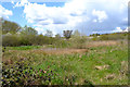
Scrub and wetland south of the Alan Higgs Centre, southeast Coventry
Guessing, the mosaic of vegetation has been allowed to develop since the construction of Allard Way. The River Sowe is behind the camera. This is public open space though not much visited.
Image: © Robin Stott
Taken: 27 Apr 2016
0.12 miles
6
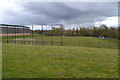
Low-level football pitch, Alan Higgs Centre, Pinley, Coventry
Viewed from the path at Centre level that runs alongside five beautifully-kept pitches behind the camera Image
Image: © Robin Stott
Taken: 30 Apr 2016
0.14 miles
7
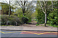
Path to the open space behind the school and a building, Chace Avenue, Willenhall
The school is St Anne's Catholic Primary School; the anonymous building on the left may be a remand centre Image The extensive open space and playing fields to the west are bounded by scrub along the River Sowe Image
Image: © Robin Stott
Taken: 30 Apr 2016
0.14 miles
8
Long straight gently-falling concrete box, near Pinley, Coventry
The assumption must be that this an important pipe encased in concrete. It is clearly used as a footpath. It emerges on the west side of Willenhall, crosses the River Sowe and disappears under the football pitches of the Alan Higgs Centre. It might be for sewage coming down or water going up: no knowing. Blackthorn is in flower.
Image: © Robin Stott
Taken: 30 Apr 2016
0.15 miles
9

Open space between the River Sowe and the back of Chace Avenue, Willenhall, Coventry
The river meanders through blackthorn scrub. The viewpoint is at the rear of Willenhall Police Station Image An icy shower was moving away east.
Image: © Robin Stott
Taken: 30 Apr 2016
0.15 miles
10
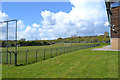
Floodlit grass football pitch, Alan Higgs Centre, Allard Way, Coventry
This is on the south side of the Centre. In the distance four or five other grass pitches extend to the west at higher level. All beautifully maintained.
Image: © Robin Stott
Taken: 27 Apr 2016
0.16 miles