IMAGES TAKEN NEAR TO
Arlington Avenue, LEAMINGTON SPA, CV32 5UD
Introduction
This page details the photographs taken nearby to Arlington Avenue, CV32 5UD by members of the Geograph project.
The Geograph project started in 2005 with the aim of publishing, organising and preserving representative images for every square kilometre of Great Britain, Ireland and the Isle of Man.

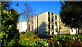
There are currently over 7.5m images from over14,400 individuals and you can help contribute to the project by visiting https://www.geograph.org.uk
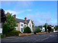
Image Map (Loading...)


Getting Data...Please wait
Leaflet Map data © OpenStreetMap
Images are licensed for reuse under creativecommons.org/licenses/by-sa/2.0
Notes
- Clicking on the map will re-center to the selected point.
- The higher the marker number, the further away the image location is from the centre of the postcode.
Image Listing (117 Images Found)
Images are licensed for reuse under creativecommons.org/licenses/by-sa/2.0
Image
Details
Distance
1
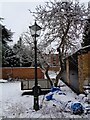
Old fashioned light, Arlington Mews
Photo of an old fashioned streetlight in Arlington Mews
Image: © Richard Lawson
Taken: 24 Jan 2021
0.05 miles
2
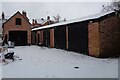
Arlington Mews in the snow
Photo of Arlington Mews in the snow, January 2021
Image: © Richard Lawson
Taken: 24 Jan 2021
0.05 miles
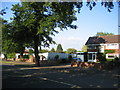
3
Demolition development progress
The new buildings on Lillington Road are starting to appear and a "marketing suite" has appeared on site alongside some carefully revealed "show homes". In fairness the design is not entirely out of keeping with the area, however the density still promises to create parking and traffic problems. See also Image
Image: © David Stowell
Taken: 10 Dec 2005
0.05 miles
4
Solar Panels & Wind Generator
The huge panel on this house is a recently installed photovoltaic array to complement the wind turbine (the first in the area under recent regulations) attached to the end of the building. The size of the panel caused some controversy when it received planning approval as many shops and business premises claimed that their applications for much smaller advertising displays were routinely refused.
Image: © David Stowell
Taken: 23 Mar 2009
0.09 miles
5
Hunters Reach, Kenilworth Road, Leamington
Apartments built by AC Lloyd circa 2010.
Image: © John Brightley
Taken: 29 Nov 2016
0.10 miles
6
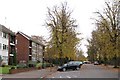
North end of Arlington Avenue
Looking south across Lillington Avenue. The avenue of limes pre-dates the 20th century flats.
Image: © Robin Stott
Taken: 23 Oct 2009
0.10 miles
7
Demolition Development
The white hoarding marks the site of three large smart 1960's houses which, despite strong local opposition have recently been demolished to make way for blocks of flats. For progress see Image
Image: © David Stowell
Taken: 21 Jul 2005
0.11 miles
8
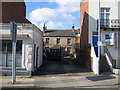
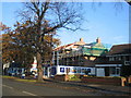
Clarendon Street
This house and yard, set back from the main street, were for many years the premises of a whitesmith.
Image: © David Stowell
Taken: 25 Feb 2006
0.11 miles
9
Boarded Up House, Kenilworth Rd
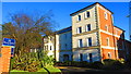
It is a long time since this building known as Homewood was used as a house and it was a hotel until 1952 when it became the MHA care home. It was a care home for 59 years until recently when a new "Homewood Care Home " was built further along the Kenilworth Rd. As can be seen the old Homewood has been boarded up. The site may be redeveloped but it is in a conservation area. The road is the old A452 which has now been rerouted away from the centre of town and this is now the B4087.
Thanks to John Brightley for the extra information.
Image: © Nigel Mykura
Taken: 26 Aug 2011
0.13 miles
10
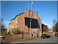
England House, Binswood Avenue, Leamington
Image: © John Brightley
Taken: 29 Nov 2016
0.13 miles