IMAGES TAKEN NEAR TO
Binley Road, COVENTRY, CV3 1HZ
Introduction
This page details the photographs taken nearby to Binley Road, CV3 1HZ by members of the Geograph project.
The Geograph project started in 2005 with the aim of publishing, organising and preserving representative images for every square kilometre of Great Britain, Ireland and the Isle of Man.

There are currently over 7.5m images from over14,400 individuals and you can help contribute to the project by visiting https://www.geograph.org.uk
Image Map
Images are licensed for reuse under creativecommons.org/licenses/by-sa/2.0
Notes
- Clicking on the map will re-center to the selected point.
- The higher the marker number, the further away the image location is from the centre of the postcode.
Image Listing (94 Images Found)
Images are licensed for reuse under creativecommons.org/licenses/by-sa/2.0
Image
Details
Distance
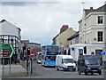
1

Path across Gosford Green towards Walsgrave Road
Gosford Green is a triangular park surrounded by busy roads to the east of Coventry city centre. Once much larger, it was the place from where in 1398, King Richard II sent Thomas de Mowbray, Earl of Norfolk, and Henry Bolingbroke into exile, cancelling the trial by combat which was to have decided the fate of the two men, each of whom had accused the other of treason. The scene is portrayed at the beginning of Shakespeare's 'Richard II'. Bolingbroke later deposed Richard and was crowned Henry IV. A street to the north of Gosford Green is named King Richard Street. There are also streets named after Mowbray and Bolingbroke in the neighbourhood.
Image: © A J Paxton
Taken: 19 May 2018
0.06 miles
2

Craft beers, Twisted Barrel brewery, Fargo Village, Coventry
Three - now two and a half - third-of-a-pint glasses of beer brewed at the Twisted Barrel craft brewery and served in its tap room, together with a cup of wasabi peas. The beer on the right looks like a porter or perhaps an imperial stout; in the centre is a fruit sour, to the left perhaps a pale ale or a light beer. The table is in the open air seating area outside the tap room and brewery. Photo taken in April 2019.
Image: © A J Paxton
Taken: 21 Apr 2019
0.06 miles
4
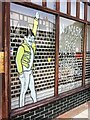
Public health message, Far Gosford Street, Coventry
Pandemic health message in the window of the Noise Works shop, which sells guitars and basses.
Image: © A J Paxton
Taken: 24 Jul 2021
0.06 miles
5

Eye mural, Fargo Village, Coventry
Detail of a giant human eye painted on a wall at the Fargo Village business centre and event space, Far Gosford Street, Coventry. In the pupil can be seen reflected an elephant and castle, heraldic symbol of the city of Coventry. The photo was taken in March 2019; the mural had recently replaced an elephant-and-castle mural.
Image: © A J Paxton
Taken: 22 Mar 2019
0.07 miles
6
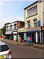
Shops of Far Gosford Street, Coventry, on the south side at the eastern end
The Al Halal supermarket occupies the ground floor of a silk ribbon weaver's house, with its distinctive large top shop window maximising the fall of natural light on the handloom and the fine, detailed work that was carried out on it. The house dates probably from the first half of the 19th century - the trade collapsed after 1860 - but Far Gosford Street has a much longer history extending back to the middle ages, when it was an eastern suburb beyond the Gosford Gate and the city walls of Coventry. Beyond Al Halal is the B&T African supermarket. https://www.coventrysociety.org.uk/news/article/new-heritage-group-for-far-gosford-street.html
Image: © A J Paxton
Taken: 24 Jul 2021
0.07 miles
7
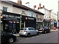
Shops of Far Gosford Street, Coventry, on the north side and eastern end
Far Gosford Street is an early suburb of Coventry that developed in the middle ages along the road east out of the city towards Leicester and London. It survived the air raids of the second world war and the redevelopment of the postwar years largely intact. It was declared a conservation area in the 1990s and in recent years has undergone a 'regeneration' programmed that has succeeded in reversing its decline without destroying its character, which rests both in its buildings and its independent businesses. https://www.coventrysociety.org.uk/news/article/new-heritage-group-for-far-gosford-street.html
This section has a row of 19th century houses and commercial buildings with stucco facades, once known as Ashville Terrace. The gardens were covered over with extended shop fronts in the early 20th century. Anedo is a Nigerian chop house and bar; beyond it are a pizza house, a guitar shop, a Polish-Ukrainian restaurant ('Slovianka'), then two of the street's many barber shops, one of them East African.
The larger three storey building beyond them was home to the Coronet Cycle Works at the end of the 19th century and later the Humber Motor Works; it was rebuilt after a fire in 1906. https://www.historiccoventry.co.uk/nowandthen/content.php?pg=humber-wks It lost its rear section to the construction of Sky Blue Way in the 1980s; the rest housed a branch of Lloyds Bank for many years. More information can be found in 'The Far Gosford Street Conservation Area: Brief History and Character Statement' at http://www.coventry.gov.uk
Image: © A J Paxton
Taken: 24 Jul 2021
0.07 miles
8
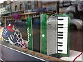
Polish-Ukrainian restaurant, Far Gosford Street, Coventry
An accordion displayed in the window of the Slovianka Polish & Ukrainian restaurant (more correctly spelled Slowianka perhaps, but Slovianka appears on the sign outside). It has since been joined by on the windowsill by a Polish weighing scale of perhaps 1950s vintage.
Image: © A J Paxton
Taken: 19 Mar 2019
0.07 miles
9
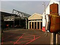
Fargo Village, Coventry: main square and covered seating area
Fargo Village is a retail and food business centre and 'creative hub' on Far Gosford Street which opened in 2014, the fruit of a partnership between Creative Developments and the City Council. https://www.coventrysociety.org.uk/news/article/fargo-village.html The name Fargo alludes to Far Gosford Street but also to the US west, and the development projects a west-coast creative-hipster vibe. The turnover of businesses appears quite high, but overall the area seems to be flourishing, helped no doubt by the presence of a craft brewery and tap room and various eateries. The covered seating area between them, with its metal-framed, factory-like roof, is a new, post-pandemic development in 2021 that encourages customers to socialise outdoors in all weathers.
Image: © A J Paxton
Taken: 24 Jul 2021
0.07 miles
10
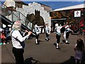
Morris dancing in Fargo Village, Far Gosford Street, Coventry
Morris men are dancing accompanied by a flautist in the main square of Fargo Village, a rather traditional performance for this chic and bohemian venue. The photo was taken in May 2018. This part of the square has since been roofed over and is used as covered but open air seating. The elephant mural has also been replaced, by a painting of a giant human eye, but this, too, features an elephant, a totem of Coventry which appears on the shield of the city coat of arms. The elephant is traditionally said to represent strength and stability, though it may have had more elaborate medieval religious symbolism also. https://www.coventry.gov.uk/info/130/lord_mayor/890/the_history_of_civic_life/2
Image: © A J Paxton
Taken: 5 May 2018
0.07 miles