IMAGES TAKEN NEAR TO
Exmouth Close, COVENTRY, CV2 3LL
Introduction
This page details the photographs taken nearby to Exmouth Close, CV2 3LL by members of the Geograph project.
The Geograph project started in 2005 with the aim of publishing, organising and preserving representative images for every square kilometre of Great Britain, Ireland and the Isle of Man.

There are currently over 7.5m images from over14,400 individuals and you can help contribute to the project by visiting https://www.geograph.org.uk
Image Map
Images are licensed for reuse under creativecommons.org/licenses/by-sa/2.0
Notes
- Clicking on the map will re-center to the selected point.
- The higher the marker number, the further away the image location is from the centre of the postcode.
Image Listing (7 Images Found)
Images are licensed for reuse under creativecommons.org/licenses/by-sa/2.0
Image
Details
Distance
1
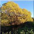
Willows by the River Sowe, Henley Green
They fit the description for crack willow, Salix fragilis, but willow species hybridise freely, according to the Woodland Trust site, with hybrid forms of crack willow and white willow, Salix alba, being especially common. It is mid-November and the leaves have turned a brilliant yellow.
Image: © A J Paxton
Taken: 11 Nov 2023
0.09 miles
2
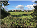
Suburban farmland, Henley Green, Coventry
Cows chew the cud on a sunny afternoon in early autumn. This pasture is in the floodplain of the River Sowe, foreground. From an aerial photo it appears to be part of Henley Farm off Henley Mill Lane. The view is from the open space to the rear of Parry Road. Looking north, we see the rear of houses in Brierley Road CV2, right, and Henley Mill Lane, left, with Henley College showing beyond it. The tower block of flats is Dewis House in Riley Square, Bell Green Image
Image: © Robin Stott
Taken: 2 Oct 2016
0.22 miles
3
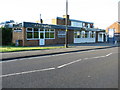
King's Cafe and Grill, Blackberry Lane
Image: © Keith Williams
Taken: 13 May 2015
0.23 miles
4
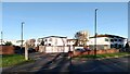
Hermes Crescent, Manor Farm, Coventry
Hermes Crescent consists of a single curving road branching off into small streets of houses on footpaths, with garages and road access on separate spurs. This is the Radburn model of housing estate design, developed in the USA from 1929, and widely used in Coventry council housing estates of the 1960s. Hermes Crescent dates from this period and formed part of Manor Farm Phase 3, together with the tower block on Caradoc Close, visible in the distance (see Image]).
The Crescent later fell on evil times, and pictures of boarded-up and burnt-out houses are not hard to find online. In the late 2010s it was 'regenerated' with extensive investment. Windows were replaced and insulating cladding fitted.
See Jeremy & Caroline Gould, Coventry: The Making of a modern city 1939-73, pp93-98, at the Historic England site https://historicengland.org.uk/images-books/publications/coventry-making-of-modern-city-1939-73/#:~:text=This%20book%20aims%20to%20inform,Coventry's%20remarkable%20post%2Dwar%20heritage.
Image: © A J Paxton
Taken: 11 Nov 2023
0.24 miles
5
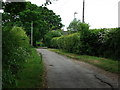
Henley Mill Lane, Coventry
A remarkably unspoilt surviving country lane within the depths of Coventry suburbia.
The farmland either side has not been built upon as it forms part of the River Sowe flood plain.
The edge of Henley College grounds are behind the hedge on the right.
Image: © John Brightley
Taken: 25 May 2010
0.25 miles
6

The Henley Mill Oak, Henley Mill Lane
This fine oak tree is growing in a hedgerow opposite Henley Farm. The Woodland Trust list it as a 'notable tree', with a girth of 5.3m, measured at the conventional height of 1.5m. https://ati.woodlandtrust.org.uk/tree-search/tree?treeid=181511&from=3523&v=2263710&ml=map&z=18&nwLat=52.42994344292339&nwLng=-1.4746649670215306&seLat=52.42874956574498&seLng=-1.467889707049912#/ It is seen here in early April and is certainly a striking local landmark. The Woodland Trust site describes it as a 'remarkable survival in such an urban area.'
Henley Mill Lane is itself a remarkable survivor, a Warwickshire country lane surrounded by 20th century Coventry suburbia and council housing estates. It lies in a loop of the River Sowe, and its location on or near the floodplain has probably discouraged building in this area.
Image: © A J Paxton
Taken: 9 Apr 2023
0.25 miles
7

The Henley Mill Oak, with Henley Green behind
This remarkable oak tree stands in a hedgerow on Henley Mill Lane, by Henley Farm, a rural oasis in urban Coventry, lying in the valley of the River Sowe. The photographer is standing to the southwest, and houses of Henley Green can be seen in the distance. Image] shows this 'notable tree' from the other direction, and includes a link to its pages on the Woodland Trust site.
Image: © A J Paxton
Taken: 6 Apr 2023
0.25 miles