IMAGES TAKEN NEAR TO
Bryanston Close, COVENTRY, CV2 2JN
Introduction
This page details the photographs taken nearby to Bryanston Close, CV2 2JN by members of the Geograph project.
The Geograph project started in 2005 with the aim of publishing, organising and preserving representative images for every square kilometre of Great Britain, Ireland and the Isle of Man.

There are currently over 7.5m images from over14,400 individuals and you can help contribute to the project by visiting https://www.geograph.org.uk
Image Map
Images are licensed for reuse under creativecommons.org/licenses/by-sa/2.0
Notes
- Clicking on the map will re-center to the selected point.
- The higher the marker number, the further away the image location is from the centre of the postcode.
Image Listing (39 Images Found)
Images are licensed for reuse under creativecommons.org/licenses/by-sa/2.0
Image
Details
Distance
2
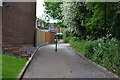
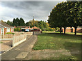
Path off Dorchester Way, Walsgrave, east Coventry
The Pearl Hyde Primary School is behind the hedge on the right.
Image: © Robin Stott
Taken: 2 Jun 2016
0.05 miles
4
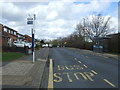
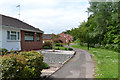
Blandford Drive, Walsgrave, Coventry
A turning off Dorchester Way.
Image: © Robin Stott
Taken: 15 Oct 2015
0.07 miles
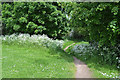
5
Footpath from Dorchester Way to the Sowe Valley footpath, Walsgrave, Coventry
One of a number of links between the residential estate and the Sowe Valley green space.
Image: © Robin Stott
Taken: 14 Oct 2015
0.08 miles
6
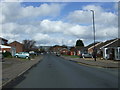
Eastern edge of the Dorchester Way estate, Walsgrave, east Coventry
The path provides access for residents; it is not the Sowe Valley footpath. The planted tree screen on the right may mark the edge of the River Sowe floodplain.
Image: © Robin Stott
Taken: 2 Jun 2016
0.12 miles
7
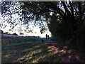
Walking the dog on Dorchester Brookstray
The walkers and their dog are heading northwards along Dorchester Brookstray; see the map of the Sowe Valley footpath on the Coventry City Council site https://www.coventry.gov.uk/downloads/file/7287/the-sowe-valley-footpath-map .
Image: © A J Paxton
Taken: 8 Oct 2022
0.14 miles
8
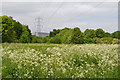
Power lines heading to or from University Hospital, Walsgrave, Coventry
This telephoto view is from the floodmeadow east of Abbotsbury Close, where the Sowe Valley path follows the river. Cow Parsley is in full bloom; hawthorn is just past. The power lines emerge from (or go) underground south of the huge hospital and appear to go underground (or emerge) to the north of it. Whether this actually is the hospital's supply is not known. Satellite images show nothing that looks like a substation. Usage must be colossal.
Image: © Robin Stott
Taken: 2 Jun 2016
0.14 miles

10
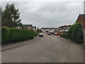
Path from the Dorchester Way estate to the Sowe Valley footpath, Walsgrave, east Coventry
The edge of the estate is behind the camera, as in Image The path drops down a bank, which probably marks the edge of the floodplain of the River Sowe. It is flowing among the trees visible through the gap. This view is the reverse of Image
Image: © Robin Stott
Taken: 2 Jun 2016
0.15 miles