IMAGES TAKEN NEAR TO
Wynne Crescent, RUGBY, CV21 1NS

Introduction

This page details the photographs taken nearby to Wynne Crescent, CV21 1NS by members of the Geograph project.

The Geograph project started in 2005 with the aim of publishing, organising and preserving representative images for every square kilometre of Great Britain, Ireland and the Isle of Man.

There are currently over 7.5m images from over14,400 individuals and you can help contribute to the project by visiting https://www.geograph.org.uk

Image Map


Images are licensed for reuse under creativecommons.org/licenses/by-sa/2.0
Notes
  • Clicking on the map will re-center to the selected point.
  • The higher the marker number, the further away the image location is from the centre of the postcode.

Image Listing (134 Images Found)

Images are licensed for reuse under creativecommons.org/licenses/by-sa/2.0
  • ...
Image
Details
Distance
1
The black path
Looking north towards Brownsover along the black path. The path connects the town centre to the substantial housing estates at Brownsover and was once the main pedestrian route from the town to the now-demolished engineering works.
Image: © Andy F Taken: 13 Jul 2009
0.03 miles
2
Rugby-Alstom Works
A row of single storey buildings running close to the footpath.
Image: © Ian Rob Taken: 20 Oct 2007
0.04 miles
3
Rugby-Alstom Works
Another vast area of the site is flattened.Image]
Image: © Ian Rob Taken: 24 Jun 2008
0.04 miles
4
Alstom works
Alstom has several sites in Rugby, this is the biggest. Taken from the footbridge over the railway looking North.
Image: © David Reid Taken: 2 May 2005
0.05 miles
5
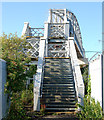
Steps up to the new black path footbridge
These steps lead from the 'black path' up onto the footbridge carrying the path over the west coast mainline railway west of Rugby station. The steps are original but the bridge itself replaces the original riveted footbridge and it opened in mid-summer 2009, the replacement project having over-run by several months. The 'black path' and footbridge connects the town centre to the substantial housing estates at Brownsover and was once the main pedestrian route from the town to the now-demolished engineering works. For a view of the old bridge and engineering works before demolition see [http://www.geograph.org.uk/photo/6771] . For a view of the new bridge under construction see [http://www.geograph.org.uk/photo/1121183] . For a view of the demolished site of the former engineering works see [http://www.geograph.org.uk/photo/861937] .
Image: © Andy F Taken: 13 Jul 2009
0.06 miles
6
Rugby-Wood Street Footbridge
The bridge over the West Coast Mainline is busy once more as it provides a direct pedestrian link from the Town Centre to the College and Junction 1 Retail Park.
Image: © Ian Rob Taken: 11 Jan 2012
0.06 miles
7
Rugby-Wood Street Bridge
A close up view of the alteration to the bridge enabling access for cyclists and wheelchair users instead of the three flights of steep steps.
Image: © Ian Rob Taken: 11 Aug 2013
0.06 miles
8
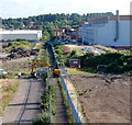
Looking north along the black path
This is the view north along the 'black path' from the footbridge over the west coast mainline railway west of Rugby station. The tracked excavator is crossing the path from one demolition site to another. The 'black path' and footbridge connects the town centre to the substantial housing estates at Brownsover and was once the main pedestrian route from the town to the now-demolished engineering works. For a view of the engineering works before demolition see [http://www.geograph.org.uk/photo/6771] . For another view of the demolished site of the former engineering works see [http://www.geograph.org.uk/photo/861937] .
Image: © Andy F Taken: 13 Jul 2009
0.06 miles
9
Rugby-Alstom Works
What appears to be another couple of redundant machine shops.
Image: © Ian Rob Taken: 20 Oct 2007
0.06 miles
10
Baker Street, Rugby
Part of the St Modwen 'Edison Place' development built on land that was part of the GEC works.
Image: © Stephen McKay Taken: 9 Mar 2021
0.06 miles
  • ...