IMAGES TAKEN NEAR TO
Lower Ford Street, COVENTRY, CV1 5PQ
Introduction
This page details the photographs taken nearby to Lower Ford Street, CV1 5PQ by members of the Geograph project.
The Geograph project started in 2005 with the aim of publishing, organising and preserving representative images for every square kilometre of Great Britain, Ireland and the Isle of Man.

There are currently over 7.5m images from over14,400 individuals and you can help contribute to the project by visiting https://www.geograph.org.uk
Image Map
Images are licensed for reuse under creativecommons.org/licenses/by-sa/2.0
Notes
- Clicking on the map will re-center to the selected point.
- The higher the marker number, the further away the image location is from the centre of the postcode.
Image Listing (194 Images Found)
Images are licensed for reuse under creativecommons.org/licenses/by-sa/2.0
Image
Details
Distance
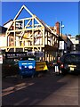
1
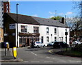
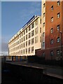
The Old Days in Coventry
Restaurant at 124 Lower Ford Street. The faint K2 sign on the front wall,
and a K2 board on the side wall, are relics of a previous occupier.
Image: © Jaggery
Taken: 18 Apr 2015
0.01 miles
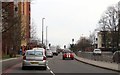
2
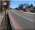
Red route, Sky Blue Way, Coventry
This part of the A4600 Sky Blue Way is a Red Route - no stopping at any time.
Image: © Jaggery
Taken: 18 Apr 2015
0.03 miles
3
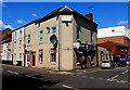
Mindi House Arabian Restaurant, Coventry
On the corner of Lower Ford Street and Hood Street. Victoria Hall is in the background.
Image: © Jaggery
Taken: 18 Apr 2015
0.04 miles
4
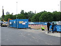
Demolition on Far Gosford Street
This land is being cleared in preparation for Gosford Gate, a £20 million student accommodation and retail development.
Image: © Keith Williams
Taken: 10 Jun 2015
0.05 miles
5
Demolition on Far Gosford Street
This land is being cleared in preparation for Gosford Gate, a £20 million student accommodation and retail development.
Image: © Keith Williams
Taken: 10 Jun 2015
0.05 miles
6
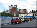
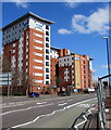
Sky Blue Point
Student accommodation overlooking Sky Blue Way, built in around 2005. Originally called Trinity Point, it was later renamed Liberty Point and then its current name, Sly Blue Point.
Image: © Ian Capper
Taken: 24 Sep 2021
0.05 miles
7
Timber-framed building under construction, Far Gosford Street
Photo taken in September 2015.
Image: © A J Paxton
Taken: 22 Sep 2015
0.05 miles
9
Self-storage warehouse, West Street, Hillfields
The building to the right is a block of student flats.
Image: © A J Paxton
Taken: 6 Jan 2024
0.06 miles
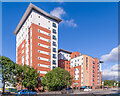
10
Multi-storey student accommodation in Coventry
Viewed across the A4600 Sky Blue Way. The nameboards show Liberty Living Trinity Point.
Image: © Jaggery
Taken: 18 Apr 2015
0.06 miles