IMAGES TAKEN NEAR TO
Berry Street, COVENTRY, CV1 5JT
Introduction
This page details the photographs taken nearby to Berry Street, CV1 5JT by members of the Geograph project.
The Geograph project started in 2005 with the aim of publishing, organising and preserving representative images for every square kilometre of Great Britain, Ireland and the Isle of Man.

There are currently over 7.5m images from over14,400 individuals and you can help contribute to the project by visiting https://www.geograph.org.uk
Image Map
Images are licensed for reuse under creativecommons.org/licenses/by-sa/2.0
Notes
- Clicking on the map will re-center to the selected point.
- The higher the marker number, the further away the image location is from the centre of the postcode.
Image Listing (24 Images Found)
Images are licensed for reuse under creativecommons.org/licenses/by-sa/2.0
Image
Details
Distance
1
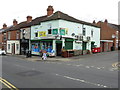
Store on the corner of Coronation Road
Image: © Keith Williams
Taken: 13 May 2015
0.01 miles
2
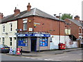
Shop on the corner of King Edward Road
Image: © Keith Williams
Taken: 13 May 2015
0.04 miles
3
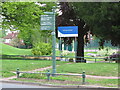
Signs in front of Primrose Hill Park
Image: © Keith Williams
Taken: 13 May 2015
0.08 miles
4
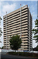
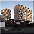
Thomas King House, Wellington Street, Coventry
One of a number of similarly-styled tower blocks dotted about the northern fringes of Coventry, standing like sentries as if to provide early warning of incursions by Nuneaton or Hinckley. They are distinguished by projecting white concrete bands and closely resemble designs by City Architect, Arthur Ling. Built by him or his successor, Terence Gregory, in the early-mid 1960s.
This one was about to be refurbished, including renewing interiors and the roof.
Image: © Stephen Richards
Taken: 22 Aug 2011
0.15 miles
5
High rise Hillfields, seen from Kildale Close
During the 1960s redevelopment of Hillfields, a war-damaged 19th century industrial district, thirteen high rise housing blocks were built by the city of Coventry. Some have since been demolished; these are two of the survivors, with some more recent low-rise housing in the foreground.
The block on the right is Hillfields House on Yardley Street, with 52 homes on ten floors. It was built by Wimpey in 1960-61 to designs by the Coventry city architect's department under Arthur Ling https://www.towerblock.eca.ed.ac.uk/development/yardley-street .
On the left is Thomas King House on Wellington Street, with 128 dwellings on 17 storeys, built 1967-8 by British Lift Slab, to designs by the same team, by then led by Terence Gregory. https://www.towerblock.eca.ed.ac.uk/development/wellington-street .
Both links are to the Edinburgh University Tower Block site. For more on Hillfields, see the Coventry Society https://www.coventrysociety.org.uk/coventry-neighbourhoods/hillfields/ .
Image: © A J Paxton
Taken: 6 Jan 2024
0.17 miles
6
Mosque, Paynes Lane, Hillfields
The mosque is called Masjid Al Madinah Al Munawwarah and is the address of the Coventry Muslim Swahili Association. It uses a former factory building in the 'moderne' style, with some curved corners and glass bricks, so perhaps of 1930s date.
Image: © A J Paxton
Taken: 6 Jan 2024
0.18 miles
7
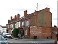
Weavers House in Hillfields
The weaving was done on the second floor, here it can be seen at the rear of the house, facing south for the light.
Image: © Keith Williams
Taken: 13 May 2015
0.18 miles
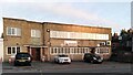
8
Coventry-Hillfields
Shops in Victoria Street.
Image: © Ian Rob
Taken: 7 Dec 2007
0.19 miles
9
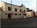
Mosque in premises of former public house, corner of Harnall Lane East and Freehold Street, Hillfields, Coventry
The Jalalabad Mosque is described by the city council as a men-only Bangladeshi mosque in the Deobandi tradition. https://cid.coventry.gov.uk/kb5/coventry/directory/service.action?id=Mg13O9a4xh0&slaction=ADD&itemid=pSOec59Tx1xkl3gGq_AA2K4y5oJOyXoBzCQPhuwD
The building was originally the Freehold Tavern and was built, with the rest of Freehold Street, around 1848, by the Freehold Land Society, which aimed to build houses that working men could buy, which would in turn give the male householder the right to vote. In 1879, the pub was renamed the Freemasons' Tavern. https://www.historiccoventry.co.uk/cph/main/pub.php?pg=freehold It appears to have closed in the 1990s. https://www.historiccoventry.co.uk/cph/main/pub.php?pg=freemasons_tavern
The exterior of the ground floor was faced with distinctive dark green glazed tiles, which can be seen in older Geograph photos, here https://www.geograph.org.uk/photo/4474195 and here https://www.geograph.org.uk/photo/3563331 . These have since been removed and replaced with beige-coloured tiles.
Image: © A J Paxton
Taken: 20 Jul 2021
0.20 miles
10
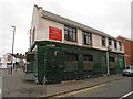
Coventry-Jalalabad Mosque And Education Centre
Converted building in Freehold Street.
Image: © Ian Rob
Taken: 20 Jul 2013
0.20 miles