IMAGES TAKEN NEAR TO
Foleshill Road, COVENTRY, CV1 4LN
Introduction
This page details the photographs taken nearby to Foleshill Road, CV1 4LN by members of the Geograph project.
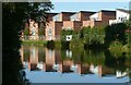
The Geograph project started in 2005 with the aim of publishing, organising and preserving representative images for every square kilometre of Great Britain, Ireland and the Isle of Man.

There are currently over 7.5m images from over14,400 individuals and you can help contribute to the project by visiting https://www.geograph.org.uk
Image Map
Images are licensed for reuse under creativecommons.org/licenses/by-sa/2.0
Notes
- Clicking on the map will re-center to the selected point.
- The higher the marker number, the further away the image location is from the centre of the postcode.
Image Listing (227 Images Found)
Images are licensed for reuse under creativecommons.org/licenses/by-sa/2.0
Image
Details
Distance
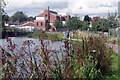
1
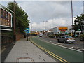
Foleshill Road
Foleshill Road (B4113) was the main road north to Nuneaton, turnpiked in 1754. The tower on the centre horizon is that of Tower Court offices ( Image] ), once part of the former Courtaulds factory.
Image: © E Gammie
Taken: 21 Oct 2009
0.01 miles
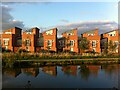
2
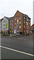
City Wharf housing development
This picture shows modern eco-friendly housing at City Wharf, Coventry. The housing in built on re-used land beside the Coventry Canal basin near the city centre.
Image: © Peter Mackenzie
Taken: 3 Jan 2017
0.01 miles
3
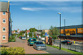
Foleshill Road
Looking alongside Foleshill Road. On the left is part of Navigation House, completed in 2015 as part of the redevelopment of a former Coventry Council site. In the far distance is Tower Court, an early 20th Century former Cortaulds factory, converted into offices c.2000.
Image: © Ian Capper
Taken: 23 Sep 2021
0.01 miles
4
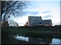
Coventry Canal, Bishopgate Green
The houses are on The Moorings, part of the City Wharf development, constructed in 2014 (Image) on the site of a former council depot.
Image: © E Gammie
Taken: 23 Dec 2019
0.02 miles
5
On reflection . . .
The Moorings. Modern housing adjacent to the Coventry Canal on site of the city's refuse destructor.
Image: © Alan Murray-Rust
Taken: 23 Sep 2021
0.03 miles
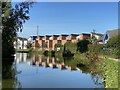

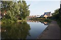
9
The Moorings, seen from across the Coventry Canal
'Architecture is frozen music' (a saying variously attributed to Goethe and Schlegel). Here we see the regular beat and leaping motifs of a housing development on a street called The Moorings in the City Wharf development in Bishopgate Green, just north of Coventry city centre. It was built in 2014, according to the comment on this geograph Image
Image: © A J Paxton
Taken: 26 Aug 2021
0.04 miles
10
Coventry Canal, north of Draper's Field
A dog gets some fuss from users of the towpath, which is now in excellent condition throughout this stretch.
Image: © Stephen McKay
Taken: 11 Sep 2021
0.04 miles