IMAGES TAKEN NEAR TO
Radford Road, COVENTRY, CV1 4EL
Introduction
This page details the photographs taken nearby to Radford Road, CV1 4EL by members of the Geograph project.
The Geograph project started in 2005 with the aim of publishing, organising and preserving representative images for every square kilometre of Great Britain, Ireland and the Isle of Man.

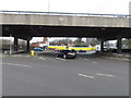
There are currently over 7.5m images from over14,400 individuals and you can help contribute to the project by visiting https://www.geograph.org.uk
Image Map
Images are licensed for reuse under creativecommons.org/licenses/by-sa/2.0
Notes
- Clicking on the map will re-center to the selected point.
- The higher the marker number, the further away the image location is from the centre of the postcode.
Image Listing (597 Images Found)
Images are licensed for reuse under creativecommons.org/licenses/by-sa/2.0
Image
Details
Distance
1
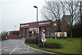
Coventry fire station
Coventry fire station, Radford Road, Coventry, West Midlands
Image: © Kevin Hale
Taken: 25 Jan 2009
0.00 miles
2
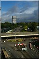
Fire station and Naul's Mill House
The 1970's fire station at the junction of Radford Road and Ringway Hill Cross undergoing demolition. It is to be replaced with an updated station on the same site. Naul's Mill House residential tower block stands in the background.
In 2007: Image]
Image: © PGJ
Taken: 15 Feb 2017
0.01 miles
3
Fire station entrance
The entrance to the 1970s-built fire station on Radford Road, during demolition work.
A comparative view in 2009: Image]
Image: © PGJ
Taken: 21 Feb 2017
0.02 miles
4
Ring road junction and fire station
Coventry Community fire station, Radford Road. This fire station replaces the 1970's-era building on this site, demolished in 2017.
Image: © E Gammie
Taken: 22 Dec 2018
0.02 miles
5
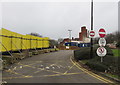
Ringway junction 9
The Radford Road exit from the inner ring road. Beyond the junction, the yellow hoardings surround the demolition site of the central fire station, constructed in the 1970s.
Image: © E Gammie
Taken: 21 Feb 2017
0.03 miles
6
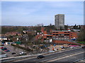
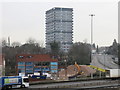
Coventry fire station
This station took over from the old fire station in Hales Street ( Image] ) in 1976. To its left are houses in Middleborough Road, Abbots Lane and Mill Street; to the right, Radford Radial spur. The tower block is Naul's Mill House, the nearby trees are in Naul's Mill Park and the dual carriageway is part of the inner ring road.
Image: © E Gammie
Taken: 6 Apr 2007
0.04 miles
7
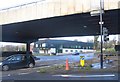
Coventry: Ringway junction and view up Radford Road
Image: © Christopher Hilton
Taken: 10 Sep 2021
0.05 miles
8
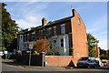
Nos. 29, 31, 33 and 35 Middleborough Road
There is an Ordnance Survey benchmark Image on the front face of the nearest house at its corner right of the grey downpipe and inside the brick boundary wall.
Image: © Roger Templeman
Taken: 19 Sep 2017
0.06 miles
9
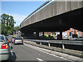
Junction 9, Coventry Ring Road CV1
Traffic is on the northbound slip road waiting to turn left into Radford Road.
Image: © Robin Stott
Taken: 9 Aug 2012
0.06 miles
10
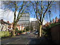
Middleborough Road
Late 19th/early 20th century housing in Middleborough Road contrasts with the 1960s tower blocks of Naul's Mill House and Samuel Vale House at the far end of the road.
Image: © E Gammie
Taken: 1 Mar 2016
0.06 miles