IMAGES TAKEN NEAR TO
Hill Street, COVENTRY, CV1 4AX
Introduction
This page details the photographs taken nearby to Hill Street, CV1 4AX by members of the Geograph project.
The Geograph project started in 2005 with the aim of publishing, organising and preserving representative images for every square kilometre of Great Britain, Ireland and the Isle of Man.

There are currently over 7.5m images from over14,400 individuals and you can help contribute to the project by visiting https://www.geograph.org.uk
Image Map
Images are licensed for reuse under creativecommons.org/licenses/by-sa/2.0
Notes
- Clicking on the map will re-center to the selected point.
- The higher the marker number, the further away the image location is from the centre of the postcode.
Image Listing (741 Images Found)
Images are licensed for reuse under creativecommons.org/licenses/by-sa/2.0
Image
Details
Distance
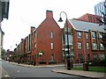
1
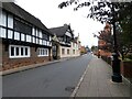
Hill Street
On the left is the Grade II* listed Bonds Hospital, founded by the will of Thomas Bond who died 1506 and much restored 1832-4.
Image: © Gerald England
Taken: 25 Sep 2021
0.01 miles
2
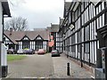
Bonds Hospital
Bonds Hospital off Hill Street. This building was founded by Thomas Bond who died 1506. The building is Grade II* listed see: https://historicengland.org.uk/listing/the-list/list-entry/1076615
Image: © Philip Halling
Taken: 13 Apr 2018
0.01 miles
3
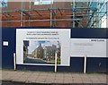
New development in Hill Street
Artist's impression of the intended appearance of Bond's Lodge sheltered accommodation under construction in Hill Street next to the existing sheltered accommodation buildings.
Image: © E Gammie
Taken: 23 Dec 2019
0.01 miles
4
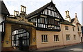
Entrance Arch to Bond's Hospital, Hill Street
There is an Ordnance Survey benchmark Image at the base of the left hand side of the arch
Image: © Roger Templeman
Taken: 19 Sep 2017
0.01 miles
5
Hill Street, Bond's Lodge
Bond's Lodge sheltered accommodation under construction, an addition to the existing buildings at the bottom of Hill Street.
Image: © E Gammie
Taken: 23 Dec 2019
0.02 miles
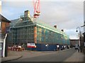
6

Construction site, Bond Street
The former Bond Street car park, disused for several years, is now a hive of activity and filled with equipment for the construction of a multi-storey student accommodation block which is well under way on the left.
In 2015: Image]
Image: © E Gammie
Taken: 20 May 2016
0.02 miles
7
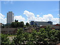
Former Bond Street car park
The old Bond Street car park has been fenced off since at least 2007 (Image]) with no activity.
Also visible around the car park are the Bond Street almshouses and old Bablake School and, in the background, Mercia House tower block, the tower of St John's church and the Ikea building.
Image: © E Gammie
Taken: 10 Jun 2014
0.02 miles
8
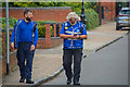
Coventry : Hill Street
Enforcement officers walking along Hill Street.
Image: © Lewis Clarke
Taken: 25 Sep 2021
0.02 miles
9
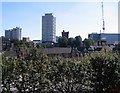
Former Bond Street car park, 2007
The former Bond Street car park is fenced off for the Belgrade Plaza redevelopment and remains so in 2014 (Image]). On the skyline are (L-R) Coventry Point in Market Way, Mercia House tower block, the crenellated tower of St John's church and an under-construction Ikea.
Image: © E Gammie
Taken: 25 Aug 2007
0.02 miles
10
Bond's Lodge, Hill Street
A sheltered accommodation development, constructed 2019-2020 on the site of the former Bond Street car park.
Image: © E Gammie
Taken: 21 Sep 2022
0.02 miles