IMAGES TAKEN NEAR TO
Gravel Castle Road, CANTERBURY, CT4 6QF
Introduction
This page details the photographs taken nearby to Gravel Castle Road, CT4 6QF by members of the Geograph project.
The Geograph project started in 2005 with the aim of publishing, organising and preserving representative images for every square kilometre of Great Britain, Ireland and the Isle of Man.

There are currently over 7.5m images from over14,400 individuals and you can help contribute to the project by visiting https://www.geograph.org.uk
Image Map
Images are licensed for reuse under creativecommons.org/licenses/by-sa/2.0
Notes
- Clicking on the map will re-center to the selected point.
- The higher the marker number, the further away the image location is from the centre of the postcode.
Image Listing (31 Images Found)
Images are licensed for reuse under creativecommons.org/licenses/by-sa/2.0
Image
Details
Distance
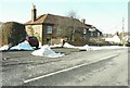
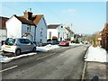
1
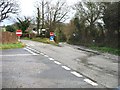
Road junction
Junction of (L to R) Mill Lane, Gravel Castle Road and Rabbit Hole.
Image: © Nick Smith
Taken: 12 Feb 2007
0.04 miles
2
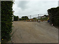
Land adjacent to Southease, Derringstone Hill
Planning permission has been granted by Canterbury City Council under application number CA//17/02393 for a “proposed detached two-storey dwelling and garage”.
A small portion of the house called Southease is visible on the left.
Image: © John Baker
Taken: 4 Jun 2019
0.11 miles
3
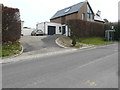
Hilltop House, Derringstone Hill
The house was built on Image It’s very handy if one wants to catch a bus (they run every two hours), as there is a stop to the right of the entrance.
Image: © John Baker
Taken: 16 Apr 2020
0.11 miles
5
Two houses on Derringstone Hill
The larger house is named Brown Cottage, the smaller - Derringstone Hill House.
Image: © John Baker
Taken: 11 Feb 2012
0.16 miles
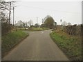
6
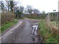
Brickfield Road, Barham
This is where Brickfield Road meets the delightfully named road ahead of Rabbit Hole. The names are fairly self explanatory. The footpath straight ahead leads to Broome Park Golf Course.
Image: © Marathon
Taken: 7 Dec 2013
0.18 miles
7
Bear House, Derringstone Hill
The house was built in the grounds of Sydney House.
Image: © John Baker
Taken: 30 May 2019
0.18 miles
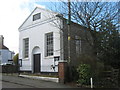
8
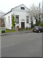
Wesleyan Chapel, Derringstone Hill
The chapel is grade II listed and dates from 1836. Judging from the weeds, either side of the path to the entrance door, it appears to have become disused.
Image: © John Baker
Taken: 16 Apr 2020
0.18 miles
9
Buildings on Derringstone Hill
The nearest house is semi-detached - the white-boarded side is named Wesley Cottage and the other Wesley House. Beyond is the Methodist Church, a converted Wesleyan chapel dated 1836.
Image: © John Baker
Taken: 11 Feb 2012
0.18 miles
10
Barham Methodist Church
A converted Wesleyan Chapel on Derringstone Hill.
Image: © David Anstiss
Taken: 26 Mar 2010
0.18 miles