IMAGES TAKEN NEAR TO
CT21 5FJ
Introduction
This page details the photographs taken nearby to CT21 5FJ by members of the Geograph project.
The Geograph project started in 2005 with the aim of publishing, organising and preserving representative images for every square kilometre of Great Britain, Ireland and the Isle of Man.

There are currently over 7.5m images from over14,400 individuals and you can help contribute to the project by visiting https://www.geograph.org.uk
Image Map
Images are licensed for reuse under creativecommons.org/licenses/by-sa/2.0
Notes
- Clicking on the map will re-center to the selected point.
- The higher the marker number, the further away the image location is from the centre of the postcode.
Image Listing (245 Images Found)
Images are licensed for reuse under creativecommons.org/licenses/by-sa/2.0
Image
Details
Distance
1
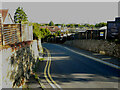
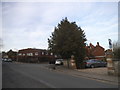
3, Tanners Hill
Planning permission has been approved, with conditions, by Folkestone and Hythe District Council under application number 20/0531/FH for the “demolition of existing dwelling and garage. Removal of conifer trees along north eastern site boundary. Proposed construction of three storey block of six apartments with parking, amenity spaces, bin & cycle stores”.
Image: © John Baker
Taken: 7 Aug 2022
0.00 miles
2
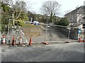
Entrance to building site at 2 Tanner?s Hill
Planning permission has been approved, with conditions, by Folkestone and Hythe District Council under application number Y11/0159/SH for the “erection of two detached three storey dwellings with upper floor set within roof space, integral garages to each house and formation of a new access to Tanner’s Hill, following demolition of existing dwelling at 5 Station Road”.
The site is now occupied by Image
Image: © John Baker
Taken: 2 Mar 2014
0.02 miles
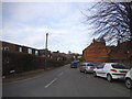
3
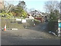
Erection of a house, Tanner?s Hill
Compared with Image, the house appears half built.
Image: © John Baker
Taken: 16 Dec 2014
0.02 miles
4
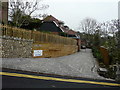
2A & 2B, Tanner?s Hill
Compared with Image, another house has been built. Two small plaques, affixed to the wooden boarding, indicate that 2A is Magnolia House and 2B is Crow’s Nest (I suppose this name refers to the further house).
Image: © John Baker
Taken: 8 Nov 2015
0.03 miles
6
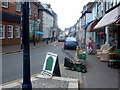
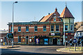
Hythe - High Street
Hythe, High Street looking west. Hythe is a small coastal market town on the edge of Romney Marsh, in the District of Shepway on the south coast of Kent. The word Hythe or Hithe is an Old English word meaning Haven or Landing Place.
Image: © Helmut Zozmann
Taken: 27 Jul 2010
0.06 miles
8
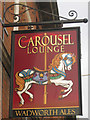
The Carousel Lounge Pub, Hythe
Prospect Road, HYTHE CT21 5JW near The Royal Military Canal
Image: © canalandriversidepubs co uk
Taken: 13 Mar 2010
0.07 miles
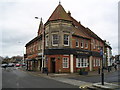
10
Carousel Lounge
Pub with an Indian and a Chinese restaurant alongside in a building dating from 1903 originally built as a hall for the Loyal Fountain of Friendship Lodge - see Image for its foundation stone.
Image: © Ian Capper
Taken: 14 Jan 2017
0.07 miles