IMAGES TAKEN NEAR TO
Dover Road, DEAL, CT14 8HQ
Introduction
This page details the photographs taken nearby to Dover Road, CT14 8HQ by members of the Geograph project.
The Geograph project started in 2005 with the aim of publishing, organising and preserving representative images for every square kilometre of Great Britain, Ireland and the Isle of Man.

There are currently over 7.5m images from over14,400 individuals and you can help contribute to the project by visiting https://www.geograph.org.uk
Image Map
Images are licensed for reuse under creativecommons.org/licenses/by-sa/2.0
Notes
- Clicking on the map will re-center to the selected point.
- The higher the marker number, the further away the image location is from the centre of the postcode.
Image Listing (13 Images Found)
Images are licensed for reuse under creativecommons.org/licenses/by-sa/2.0
Image
Details
Distance
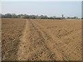
1

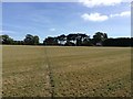
Farmland, Ringwould
Planning permission was refused by Dover District Council under application number DOV/16/00626 for a “change of use of land and erection of a building to be used as a water bottling plant to include storage and offices, with new vehicular access, parking and turning areas and associated landscaping (existing buildings to be demolished)”.
The existing buildings, which would have had to be demolished, are those of Ringwould Alpine Nursery Image, situated on Dover Road (A256), to make way for a new road from the A256 to the bottling plant.
The council cited that the bottling plant would result in disturbance to householders, along the A256, overlooking the site from their back gardens, with regard to noise and lights caused by vehicles entering and leaving the site. A major consideration for refusal was that the site lies in the Kent Downs Area of Outstanding Natural Beauty.
See also Image for the view to the east of the tree.
Image: © John Baker
Taken: 8 Nov 2018
0.09 miles

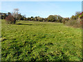
3

Footpath to Free Down Wood
A path leads from Dover Road near Ringwould, through a field and then The Lynch (field boundary wood) and then onto the wood near East Valley Farm.
Image: © David Anstiss
Taken: 27 Mar 2011
0.16 miles
4
Footpath to Ringwould (2)
This field path leads from The Lynch (field boundary wood) towards Dover Road in the village. On the right is a farm on Ringwould Road.
Image: © David Anstiss
Taken: 27 Mar 2011
0.16 miles
5
Farmland, Ringwould
Planning permission was refused by Dover District Council under application number DOV/16/00626 for a “change of use of land and erection of a building to be used as a water bottling plant to include storage and offices, with new vehicular access, parking and turning areas and associated landscaping (existing buildings to be demolished)”.
The existing buildings, which would have had to be demolished, are those of Ringwould Alpine Nursery Image, situated on Dover Road (A256), to make way for a new road from the A256 to the bottling plant.
The council cited that the bottling plant would result in disturbance to householders, along the A256, overlooking the site from their back gardens, with regard to noise and lights caused by vehicles entering and leaving the site. A major consideration for refusal was that the site lies in the Kent Downs Area of Outstanding Natural Beauty.
A footpath runs from the A256, through the trees on the right, to emerge onto and cross farmland towards Oxyneybottom Wood.
Image: © John Baker
Taken: 8 Nov 2018
0.16 miles
6
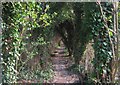
Footpath to Ringwould (3)
A path from Free Down Wood, leads through a large field and then through this green tunnel towards Dover Road in Ringwould.
Image: © David Anstiss
Taken: 27 Mar 2011
0.17 miles
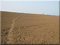
7
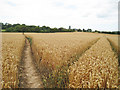
Tracks in Wheat Field
Footpath to Ringwould crossing tractor path.
Image: © Oast House Archive
Taken: 5 Aug 2010
0.21 miles
8
Hangman's Lane bridleway to Ringwould
Hangman's Lane across an arable field looking towards Ringwould. This is public bridleway ER16.
Image: © Hugh Craddock
Taken: 3 Sep 2016
0.22 miles
10
Footpath to Ringwould
This field path leads from The Lynch (field boundary wood) towards Dover Road in the village.
Image: © David Anstiss
Taken: 27 Mar 2011
0.22 miles