IMAGES TAKEN NEAR TO
Gore Road, SANDWICH, CT13 0LS
Introduction
This page details the photographs taken nearby to Gore Road, CT13 0LS by members of the Geograph project.
The Geograph project started in 2005 with the aim of publishing, organising and preserving representative images for every square kilometre of Great Britain, Ireland and the Isle of Man.

There are currently over 7.5m images from over14,400 individuals and you can help contribute to the project by visiting https://www.geograph.org.uk
Image Map
Images are licensed for reuse under creativecommons.org/licenses/by-sa/2.0
Notes
- Clicking on the map will re-center to the selected point.
- The higher the marker number, the further away the image location is from the centre of the postcode.
Image Listing (176 Images Found)
Images are licensed for reuse under creativecommons.org/licenses/by-sa/2.0
Image
Details
Distance
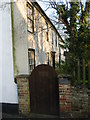
4
Becket's on junction of Gore Road and Woodnesborough Lane
In the privately owned grounds of Becket's is the entrance to Eastry caves. There is much speculation as to the origin of the labyrinth of caves, which are beautifully carved and extend in galleries to nearly seven hundred feet; these caves may have been used for secret worship in times of religious persecution and were possibly the grain storage chambers for Britain. from http://www.open-sandwich.co.uk/places_to_visit/villages/eastry.htm It is said that Thomas a Becket hid in these caves before making his escape to France in 1164.
Image: © Nick Smith
Taken: 10 Jan 2009
0.03 miles
5
Becket's, historic building of Kent
The house is privately owned, in the grounds of the house is the entrance to Eastry caves. There is much speculation as to the origin of the labyrinth of caves, which are beautifully carved and extend in galleries to nearly seven hundred feet; these caves may have been used for secret worship in times of religious persecution and were possibly the grain storage chambers for Britain. from http://www.open-sandwich.co.uk/places_to_visit/villages/eastry.htm It is said that Thomas a Becket hid in these caves before making his escape to France in 1164.
Image: © Nick Smith
Taken: 10 Jan 2009
0.04 miles
6
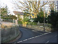
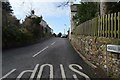
Junction of Gore Road with Woodnesborough Lane
The house is Becket's, in the private grounds of which is the entrance to Eastry caves. There is much speculation as to the origin of the labyrinth of caves, which are beautifully carved and extend in galleries to nearly seven hundred feet; these caves may have been used for secret worship in times of religious persecution and were possibly the grain storage chambers for Britain. from http://www.open-sandwich.co.uk/places_to_visit/villages/eastry.htm It is said that Thomas a Becket hid in these caves before making his escape to France in 1164.
Image: © Nick Smith
Taken: 10 Jan 2009
0.04 miles
7
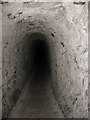
Eastry chalk caves
Exact location and view direction very difficult to estimate. Somewhere under Eastry village hall or car park! Eastry Chalk Mine was started in 1811 for a lime burning business and remained in production until 1914. Mining ceased when local villagers began to voice their concerns that their properties were in danger of collapse because of the mining beneath them. The tunnels were then used to hold local festivities. See http://www.undergroundkent.co.uk/eastrymine.htm
Image: © Nick Smith
Taken: 20 May 2009
0.04 miles
8
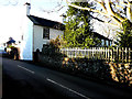
Beckets, Woodnesborough Lane
Planning permission has been granted by Dover District Council under application number DOV/18/00856 for “demolition of chimney and creation of new external opening. Insertion of glazed doors”.
The house is grade II listed. It was built around the 17th century, extended and altered in the early 19th century https://britishlistedbuildings.co.uk/101070192-beckets-eastry#.XGMVEP43bcc
Image: © John Baker
Taken: 3 Feb 2019
0.05 miles
10
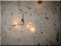
Early graffiti in Eastry caves
Various visitor graffiti in Eastry caves, many of the long established village family names can be found on the walls. Exact location and view direction very difficult to estimate. Eastry Chalk Mine was started in 1811 for a lime burning business and remained in production until 1914. See http://www.undergroundkent.co.uk/eastrymine.htm
Image: © Nick Smith
Taken: 20 May 2009
0.05 miles