IMAGES TAKEN NEAR TO
Dunheved Close, THORNTON HEATH, CR7 6AQ
Introduction
This page details the photographs taken nearby to Dunheved Close, CR7 6AQ by members of the Geograph project.
The Geograph project started in 2005 with the aim of publishing, organising and preserving representative images for every square kilometre of Great Britain, Ireland and the Isle of Man.

There are currently over 7.5m images from over14,400 individuals and you can help contribute to the project by visiting https://www.geograph.org.uk
Image Map
Images are licensed for reuse under creativecommons.org/licenses/by-sa/2.0
Notes
- Clicking on the map will re-center to the selected point.
- The higher the marker number, the further away the image location is from the centre of the postcode.
Image Listing (48 Images Found)
Images are licensed for reuse under creativecommons.org/licenses/by-sa/2.0
Image
Details
Distance
1
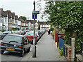
Whitehall Road, Thornton Heath
Meeting Broughton Road at the end.
Image: © Robin Webster
Taken: 6 Jun 2011
0.09 miles
3
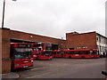
Thornton Heath Bus Garage
As seen from Whitehall Road.
Image: © David Anstiss
Taken: 30 Oct 2011
0.14 miles
4
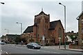
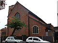
St Jude with St Aidan, Thornton Heath
A Church of England church, built 1926-29.
Image: © Robin Webster
Taken: 6 Jun 2011
0.14 miles
5
St. Jude with St. Aidan Church, Thornton Heath
Large church on the junction of Thornton Road and Gonville Road.
Image: © David Anstiss
Taken: 30 Oct 2011
0.15 miles
6
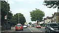
Thornton Road, heading towards Thornton Heath Pond
Thornton Road forms the north end of the A23's route around Croydon town centre, the route created in the 1920s by the building of Purley Way, and carries heavy traffic as a result.
Image: © Christopher Hilton
Taken: 23 Jul 2013
0.16 miles
8
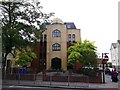
Croydon Mosque and Islamic Centre
On the junction of the A235 London Road (in front) and Dunheved Road South (on the right).
A masjid (temple) for daily five prayers.
Image: © David Anstiss
Taken: 30 Oct 2011
0.16 miles
9
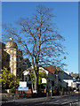
Tree, London Road
A stately tree roughly opposite the Mayday Hospital.
I thought this was an ash, but Mick Crawley suggests that it is a Robinia.
Image: © Stephen Richards
Taken: 25 Nov 2012
0.17 miles
10
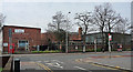
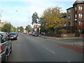
Bus garage, London Road
At Thornton Heath near the junction of London and Thornton Roads. The buildings look as if they date from the 1960s.
Image: © Stephen Richards
Taken: 20 Mar 2011
0.18 miles