IMAGES TAKEN NEAR TO
Cleave Prior, COULSDON, CR5 3YF
Introduction
This page details the photographs taken nearby to Cleave Prior, CR5 3YF by members of the Geograph project.
The Geograph project started in 2005 with the aim of publishing, organising and preserving representative images for every square kilometre of Great Britain, Ireland and the Isle of Man.

There are currently over 7.5m images from over14,400 individuals and you can help contribute to the project by visiting https://www.geograph.org.uk
Image Map
Images are licensed for reuse under creativecommons.org/licenses/by-sa/2.0
Notes
- Clicking on the map will re-center to the selected point.
- The higher the marker number, the further away the image location is from the centre of the postcode.
Image Listing (36 Images Found)
Images are licensed for reuse under creativecommons.org/licenses/by-sa/2.0
Image
Details
Distance
1
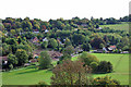
Redevelopment on Outwood Lane
Four fairly modern detached houses with double garages have been demolished to create the brownfield site in Chipsted Bottom. What profit-making development will take their place? It will be handy for the Ramblers Rest pub at the right.
Image: © Robin Webster
Taken: 6 Oct 2010
0.05 miles
2
New Development
New housing development opposite Ramblers Rest
Image: © Kurseong Carl
Taken: 24 Apr 2012
0.06 miles
3
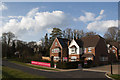
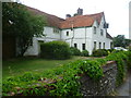
The Ramblers Rest, Outwood Lane, Chipstead Bottom
The only word for this pub-restaurant is 'rambling'. An interesting survival, timber-framed and weather-boarded, in a style which was once widespread in this part of England. Apart from a few ancient barns, it has to be one of the largest weather-boarded buildings I have seen - bigger than Image
Image: © Stefan Czapski
Taken: 22 Mar 2012
0.07 miles
4
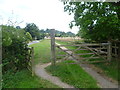
Chipstead Bottom looking towards 'The Ramblers Rest'
Outwood Lane has no pavements through the stretch between Hazelwood Lane and here so it is handy to have a tarmac footpath through Chipstead Bottom on the other side of the hedge from Outwood Lane. Here the path returns to running next to the road on its way to The Ramblers Rest ahead.
Image: © Marathon
Taken: 14 Aug 2013
0.08 miles
5
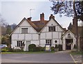
The Ramblers Rest, Chipstead Bottom: view from the north
A large pub-restaurant, timber-framed, partly weather-boarded, and plainly a few centuries old.
Image: © Stefan Czapski
Taken: 22 Mar 2012
0.08 miles
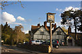
6
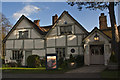
Ramblers Rest
A refreshment stop for walkers of Banstead Wood as well as a popular eating place for the locals
Image: © Kurseong Carl
Taken: 24 Apr 2012
0.08 miles
7
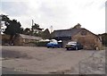
The Rambler's Rest car park, Chipstead
On Outwood Lane, the pub itself is just to the left.
Image: © David Howard
Taken: 29 Sep 2014
0.08 miles
9
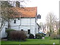
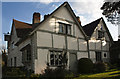
The Ramblers Rest, Outwood Lane
A plaque on the other side of the pub says: "This house dates from the reign of Queen Elizabeth I. It stands on the site of a 13th century farmhouse which was called Dene Farm until 1993. Records of the house and its occupants exist from 1301 until the present day." It only became a pub in 1993.
Image: © Marathon
Taken: 14 Aug 2013
0.09 miles
10
Ramblers Rest
Favoured haunt of walkers of Banstead Woods
Image: © Kurseong Carl
Taken: 24 Apr 2012
0.09 miles