IMAGES TAKEN NEAR TO
Deepfield Way, COULSDON, CR5 2SR
Introduction
This page details the photographs taken nearby to Deepfield Way, CR5 2SR by members of the Geograph project.
The Geograph project started in 2005 with the aim of publishing, organising and preserving representative images for every square kilometre of Great Britain, Ireland and the Isle of Man.

There are currently over 7.5m images from over14,400 individuals and you can help contribute to the project by visiting https://www.geograph.org.uk
Image Map
Images are licensed for reuse under creativecommons.org/licenses/by-sa/2.0
Notes
- Clicking on the map will re-center to the selected point.
- The higher the marker number, the further away the image location is from the centre of the postcode.
Image Listing (92 Images Found)
Images are licensed for reuse under creativecommons.org/licenses/by-sa/2.0
Image
Details
Distance
1
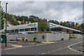
Ullswater Crescent
Access road into the Ullswater Industrial Estate in the former Stoats Nest Quarry, which operated from the early 19th Century until the 1960s, the cliffs of which can be seen in the background of the photo. The building on the right is on the site of the lime kilns of Coulsdon Lime Works which processed the chalk from the quarry.
Image: © Ian Capper
Taken: 27 Oct 2018
0.09 miles
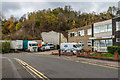
2
Ullswater Crescent
Access road into the Ullswater Industrial Estate in the former Stoats Nest Quarry, which operated from the early 19th Century until the 1960s, the cliffs of which can be seen in the background of the photo. The building in the middle distance is on the site of the lime kilns of Coulsdon Lime Works which processed the chalk from the quarry.
Image: © Ian Capper
Taken: 27 Oct 2018
0.10 miles
3
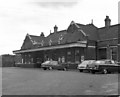
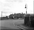
Coulsdon North station
This pleasant and useful terminus was, sadly, closed on 30 September 1983, forcing yet more traffic onto the roads.
Image: © Dr Neil Clifton
Taken: 27 May 1979
0.12 miles
4
Redlands/Ullswater Crescent
Roundabout where Redlands (in the background) meets Ullswater Crescent. The latter is the access road into the Ullswater Industrial Estate in the former Stoats Nest Quarry, which operated from the early 19th Century until the 1960s.
Image: © Ian Capper
Taken: 27 Oct 2018
0.13 miles
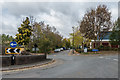
6
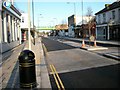
Christmas Day 3pm
Went out for a little walk as I knew nobody would be around which I reckon makes this an interesting picture.
Image: © Martin Miles
Taken: 1 Jan 2009
0.14 miles

8
Coulsdon North station
This shows the frontage of the ex-LBSCR Coulsdon North station, with one of the gas lamps which were used to light both the station and Station Approach Road. This site is now buried beneath the Coulsdon Bypass.
Image: © Dr Neil Clifton
Taken: 27 May 1979
0.14 miles
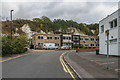
9
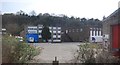
Waitrose.com
Distribution centre for the supermarket Waitrose's internet grocery channel in Ullswater Industrial Estate. The industrial estate is situated in the former Stoats Nest Quarry, which operated from the early 19th Century until the 1960s, the cliffs of which can be seen in the background of the photo.
Image: © Ian Capper
Taken: 27 Oct 2018
0.14 miles
10
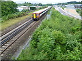
Site of Coulsdon North station
In this view from the footbridge near Coulsdon Town station, the fast lines are nearer the camera and the slow lines are beyond. Coulsdon North station was located here, straddling all four tracks. It was opened as 'Stoats Nest and Cane Hill' in 1899 and went through several different names before being closed as Coulsdon North in 1983. It is only a very short walk to Smitham (now Coulsdon Town) station (see http://www.geograph.ie/photo/3045242 ) and this was one of the reasons it was closed. More information about Coulsdon North station can be found at http://en.wikipedia.org/wiki/Coulsdon_North_railway_station and http://www.disused-stations.org.uk/c/coulsdon_north/index.shtml In this photograph a Gatwick Express heads non-stop towards London Victoria.
Image: © Marathon
Taken: 18 Jul 2012
0.15 miles