IMAGES TAKEN NEAR TO
Coulsdon Rise, COULSDON, CR5 2SA
Introduction
This page details the photographs taken nearby to Coulsdon Rise, CR5 2SA by members of the Geograph project.
The Geograph project started in 2005 with the aim of publishing, organising and preserving representative images for every square kilometre of Great Britain, Ireland and the Isle of Man.

There are currently over 7.5m images from over14,400 individuals and you can help contribute to the project by visiting https://www.geograph.org.uk
Image Map
Images are licensed for reuse under creativecommons.org/licenses/by-sa/2.0
Notes
- Clicking on the map will re-center to the selected point.
- The higher the marker number, the further away the image location is from the centre of the postcode.
Image Listing (32 Images Found)
Images are licensed for reuse under creativecommons.org/licenses/by-sa/2.0
Image
Details
Distance
2
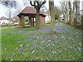
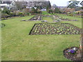
Crocuses and shelter in Chaldon Way Gardens
Chaldon Way Gardens was given to the Urban District Council by the developer, Fairdean Heights Ltd, who built the surrounding houses during the 1930s. The Company also allowed the Council to collect and use free of charge "such earth, turf, sub-soil, flowers and shrubs as can be removed from the Company's Fairdean Heights Estate" to create the Gardens. The ornamental garden were constructed with lawns, shrub beds and annual bedding displays, and a small shelter at one end of the garden. The shelter can be seen here along with a display of crocuses. Chaldon Way Gardens are in the angle formed by Marlpit Lane and Chaldon Way.
Image: © Marathon
Taken: 27 Mar 2013
0.11 miles
3
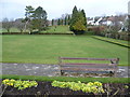
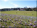
The bowling green at Coulsdon Memorial Ground
Coulsdon Memorial Ground was opened in 1921 after being purchased in 1920, partly by Coulsdon and Purley Urban District Council and partly by public subscription. The putting green area was purchased several years later. At the top of the hill there is a memorial which takes the form of a portico with a wall bearing the names of those killed in the two World Wars. This has the inscription "To the memory of the men of Coulsdon who fell in the Great War 1914-1919." A bronze plaque was added bearing the words "and in memory of those who fell in the World War 1939-1945."
To the rear of the recreation ground are deep chalk quarries which in the past had spur lines from the nearby railway running into the slopes to transport the extracted stone. This view looks across the bowling green from Marlpit Lane.
Image: © Marathon
Taken: 27 Mar 2013
0.11 miles
4
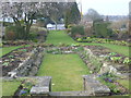
Chaldon Way Gardens
Chaldon Way Gardens was given to the Urban District Council by the developer, Fairdean Heights Ltd, who built the surrounding houses during the 1930s. The Company also allowed the Council to collect and use free of charge "such earth, turf, sub-soil, flowers and shrubs as can be removed from the Company's Fairdean Heights Estate" to create the Gardens. Chaldon Way Gardens are in the angle formed by Marlpit Lane and Chaldon Way.
Image: © Marathon
Taken: 27 Mar 2013
0.12 miles
5
Chaldon Way Gardens
Chaldon Way Gardens was given to the Urban District Council by the developer, Fairdean Heights Ltd, who built the surrounding houses during the 1930s. The Company also allowed the Council to collect and use free of charge "such earth, turf, sub-soil, flowers and shrubs as can be removed from the Company's Fairdean Heights Estate" to create the Gardens. Chaldon Way Gardens are in the angle formed by Marlpit Lane and Chaldon Way.
Image: © Marathon
Taken: 27 Mar 2013
0.12 miles
7
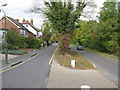
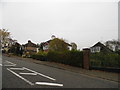
Downs Road, Coulsdon
Looking north. In spite of appearances, this is not a dual-carriageway, but two separate roads, both bi-directional. The left-hand road is Downs Road, and serves the houses. The other road is Ditches Lane, leading to Farthing Downs and Chaldon.
Image: © Dr Neil Clifton
Taken: 18 Oct 2009
0.18 miles
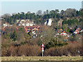
8
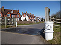
City Of London Boundary Post
This is the gate at the north end of Farthing Down, one of seven areas of land purchased in the late 19th century by the Corporation of London especially for public access.
The Corporation were concerned that development was engulfing so much land that Londoners would soon have no access to open country within easy reach.
Looking at the map, it's still fair to say that these houses beyond the gate are the edge of joined up suburbia. More open scenery begins here.
Info on the City Commons on http://www.cityoflondon.gov.uk/things-to-do/green-spaces/city-commons/Pages/City-Commons.aspx
Image: © Des Blenkinsopp
Taken: 2 Apr 2013
0.18 miles
9
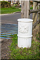
City of London Corporation post
Post with the crest of the City of London Corporation situated at the entrance to Farthing Downs off Downs Road. Farthing Downs is one of seven areas of open spaces in south London and Surrey owned by the City of London Corporation, known collectively as the City Commons. For a wider view of the entrance, see Image
Image: © Ian Capper
Taken: 27 Oct 2018
0.19 miles
10
Former quarry, Coulsdon
Presumably for the extraction of chalk. Housing and an industrial estate now cover the site.
Image: © Stephen Richards
Taken: 21 Jan 2017
0.19 miles