IMAGES TAKEN NEAR TO
Hillars Heath Road, COULSDON, CR5 2JP
Introduction
This page details the photographs taken nearby to Hillars Heath Road, CR5 2JP by members of the Geograph project.
The Geograph project started in 2005 with the aim of publishing, organising and preserving representative images for every square kilometre of Great Britain, Ireland and the Isle of Man.

There are currently over 7.5m images from over14,400 individuals and you can help contribute to the project by visiting https://www.geograph.org.uk
Image Map
Images are licensed for reuse under creativecommons.org/licenses/by-sa/2.0
Notes
- Clicking on the map will re-center to the selected point.
- The higher the marker number, the further away the image location is from the centre of the postcode.
Image Listing (229 Images Found)
Images are licensed for reuse under creativecommons.org/licenses/by-sa/2.0
Image
Details
Distance
1
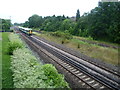
Site of Coulsdon North station
In this view from the footbridge near Coulsdon Town station, the fast lines are nearer the camera and the slow lines are beyond. Coulsdon North station was located here, straddling all four tracks. It was opened as 'Stoats Nest and Cane Hill' in 1899 and went through several different names before being closed as Coulsdon North in 1983. It is only a very short walk to Smitham (now Coulsdon Town) station (see http://www.geograph.ie/photo/3045242 ) and this was one of the reasons it was closed. More information about Coulsdon North station can be found at http://en.wikipedia.org/wiki/Coulsdon_North_railway_station and http://www.disused-stations.org.uk/c/coulsdon_north/index.shtml
Image: © Marathon
Taken: 18 Jul 2012
0.05 miles
2
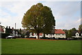
Stoats Nest Village (3)
This splendid plane tree which stands on the south-west corner of the green, is probably quite a bit older than the houses
Image: © Dr Neil Clifton
Taken: 15 Oct 2007
0.06 miles
3
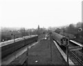
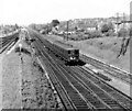
View north from Coulsdon North station
An empty 4-SUB unit occupies Platform 2, while an express unit from the coast speeds northwards through the disused Platform 3. Coulsdon North signal box was still there when this photograph was taken in 1981.
Image: © Dr Neil Clifton
Taken: 22 Feb 1981
0.06 miles
4

4-SUB units passing Coulsdon North signal box
Heavy snow falls on the morning of 8 December 1981 as BR Class 405 4-SUB units 4284 and 4293 pass Coulsdon North signal box and cross over from the Down Quarry line into Coulsdon North station. Both units were to be withdrawn the following year, and the station closed and the signal box abolished soon after.
Image: © Colin Clifton
Taken: 8 Dec 1981
0.08 miles
5
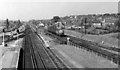
Coulsdon North Station Approach
A parcels train approaching Coulsdon North hauled by the ubiquitous Type 3. Taken in the late 60's or very early 70's on a summer day.
Image: © Ian Mockford
Taken: Unknown
0.08 miles
6

Stoats Nest Village (4)
Showing the houses along the west side of the green
Image: © Dr Neil Clifton
Taken: 15 Oct 2007
0.09 miles
8
Coulsdon North Station Approach
Southern suburban rail scene. Taken some time in the late 60's or very early 70's on a summer day, if I remember correctly.
Image: © Ian Mockford
Taken: Unknown
0.10 miles
9
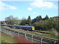
First Capital Connect train at Coulsdon
Image: © Stacey Harris
Taken: 11 Apr 2010
0.10 miles
10
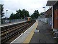
Coulsdon Town (formerly Smitham) station
A branch line along the Chipstead valley from the Brighton Main Line was first projected in 1884. This scheme failed to take off. The line from Purley East Junction to Kingswood & Burgh Heath was eventually opened on 2nd November 1897 as a single track and this was doubled during 1899. The line finally reached Tattenham Corner on 4th June 1901 - Derby Day. Smitham station was opened on 1st January 1904, and briefly closed during the First World War. It lies on a sharp curve, where the line swings away westwards from the Brighton Main Line, and is immediately adjacent to the closed Coulsdon North station on the Main Line, whose passenger traffic was diverted here when the latter closed on 3rd October 1983. The Coulsdon relief road, opened in December 2006 as part of the A23, passes underneath the station and meant that some changes to the platform access routes was required. Consequently, no direct access to the London-bound platform now exists; access is only via the other platform and a new footbridge or a lift. A new station building on the down side of the line (seen here), and a standard-pattern accessible footbridge were opened in 2010.
The Department for Transport requested that, following lobbying by Croydon Council, the train company look into a better name for the station, as Smitham was no longer used as the name of the local area, and the station was close to the centre of Coulsdon. The name chosen, after an exercise in local democracy, was Coulsdon Town. The change took place on Sunday 22nd May 2011.
Image: © Marathon
Taken: 18 Jul 2012
0.10 miles