IMAGES TAKEN NEAR TO
Dobles Close, COULSDON, CR5 2EZ
Introduction
This page details the photographs taken nearby to Dobles Close, CR5 2EZ by members of the Geograph project.
The Geograph project started in 2005 with the aim of publishing, organising and preserving representative images for every square kilometre of Great Britain, Ireland and the Isle of Man.

There are currently over 7.5m images from over14,400 individuals and you can help contribute to the project by visiting https://www.geograph.org.uk
Image Map
Images are licensed for reuse under creativecommons.org/licenses/by-sa/2.0
Notes
- Clicking on the map will re-center to the selected point.
- The higher the marker number, the further away the image location is from the centre of the postcode.
Image Listing (324 Images Found)
Images are licensed for reuse under creativecommons.org/licenses/by-sa/2.0
Image
Details
Distance
1
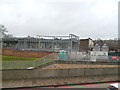
Coulsdon: New construction
I have no idea what the purpose or intention is, for the huge metallic construction that has appeared here recently.
Image: © Dr Neil Clifton
Taken: 4 Jan 2014
0.00 miles
2

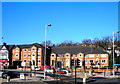
North Coulsdon
A view of the North end of Coulsdon town from the elevated pedestrian footpath constructed alongside Smitham Station and bridging the London-Brighton railway line.
Image: © Kurseong Carl
Taken: 19 Feb 2012
0.01 miles
3
Coulsdon: Emerald House, Brighton Road
Retirement homes for the active elderly.
Image: © Dr Neil Clifton
Taken: 1 Mar 2010
0.02 miles
4
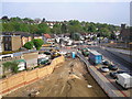
Northern end of Coulsdon Inner Relief Road
Seven years of devastation has been endured and sixteen perfectly good houses demolished in order to create this traffic jam. To see a picture from almost the same viewpoint taken four years earlier, in 2003 Image
Image: © Dr Neil Clifton
Taken: 26 Apr 2007
0.02 miles
5
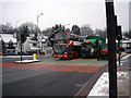
North end of Coulsdon Inner Relief Road
After a light powdering of snow. This traffic is southbound. The bus will turn right to serve Coulsdon Town Centre, while the other traffic will use the bypass to avoid the centre.
Image: © Dr Neil Clifton
Taken: 24 Jan 2007
0.02 miles
6
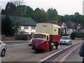
Mechanical Horse
The mechanical horse was a vehicle much used by railway goods departments from the 1930s as real horses were being phased out. They lasted well into British Railways days. Fortunately this fine example was preserved.
Image: © Dr Neil Clifton
Taken: 6 May 2007
0.02 miles
7
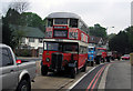
Class 'ST' bus
STs have not run in London passenger service since the immediate postwar years, but this fine preserved example was seen in the Historic Commercial Vehicle rally. Interestingly it displays blinds for Route 59, a number associated with the Croydon area for many years.
Image: © Dr Neil Clifton
Taken: 6 May 2007
0.02 miles
8
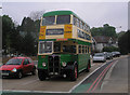
Ipswich Corporation bus
The Corporation Bus was a reliable and re-assuring part of life in Britain's provincial towns and cities, which seemed in many ways to be a permanent fixture. Now all are gone, swept away in the early 1980s by a tide of Thatcherisation. A few, like this excellent example from Ipswich, were preserved and appear occasionally to remind us what a nice place England used to be.
Image: © Dr Neil Clifton
Taken: 6 May 2007
0.02 miles
9

North end of Coulsdon Bypass
About two years ago, this bypass opened for traffic. The northern junction with the A23 has not proved very successful. On Monday 25 January 2010 work will begin to alter this junction, so these photographs are designed to record the appearance of the junction before work begins.
This is looking northeast from the Coulsdon shopping area. The Methodist Church is on the right.
Image: © Dr Neil Clifton
Taken: 21 Jan 2010
0.02 miles
10
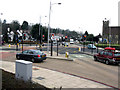
North end of Coulsdon Bypass
About two years ago, this bypass opened for traffic. The northern junction with the A23 has not proved very successful. On Monday 25 January 2010 work will begin to alter this junction, so these photographs are designed to record the appearance of the junction before work begins.
This is looking north towards the existing A23. The bypass is behind the camera to the right. Methodist Church of the right.
Image: © Dr Neil Clifton
Taken: 21 Jan 2010
0.02 miles