IMAGES TAKEN NEAR TO
Western Road, MITCHAM, CR4 3ED
Introduction
This page details the photographs taken nearby to Western Road, CR4 3ED by members of the Geograph project.
The Geograph project started in 2005 with the aim of publishing, organising and preserving representative images for every square kilometre of Great Britain, Ireland and the Isle of Man.

There are currently over 7.5m images from over14,400 individuals and you can help contribute to the project by visiting https://www.geograph.org.uk
Image Map (Loading...)


Getting Data...Please wait
Leaflet Map data © OpenStreetMap
Images are licensed for reuse under creativecommons.org/licenses/by-sa/2.0
Notes
- Clicking on the map will re-center to the selected point.
- The higher the marker number, the further away the image location is from the centre of the postcode.
Image Listing (74 Images Found)
Images are licensed for reuse under creativecommons.org/licenses/by-sa/2.0
Image
Details
Distance
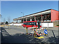
1
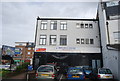
Shops on the corner of Love Lane
According to one local person, the site was a former burial ground and remains were found when the shops were built in the 1980s.
Image: © Stephen Craven
Taken: 26 Aug 2008
0.05 miles
2
Flats at Mitcham
The red brick of Gladstone House (left) and Fountain House glowing in afternoon sunshine, seen from Love Lane. There is a smaller third block, Chart House, off to the left.
Image: © Derek Harper
Taken: 16 Nov 2010
0.06 miles
3
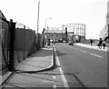
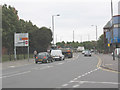
Western Road, Mitcham
Part of the A236 and a convenient route through towards the western half of London. The roadhas changed considerably in appearance since this 1980 view.
Image: © Dr Neil Clifton
Taken: 22 Mar 1980
0.06 miles
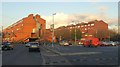
4
Building site, Mitcham
The large retail building across the road is being very heavily converted.
Image: © Robin Webster
Taken: 1 Apr 2012
0.07 miles
5
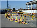
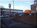
Road up, Mitcham
Western Road, by the gasworks on the left.
Image: © Robin Webster
Taken: 1 Apr 2012
0.08 miles
6
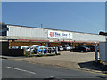
Former retail store, Mitcham
In the course of (I think) being heavily converted. Externally this was to remove all the sheet cladding and replace with brick.
Image: © Robin Webster
Taken: 1 Apr 2012
0.09 miles
7
Westfields - redeveloped
This is roughly the view in Image looking the other way, but many years later. According to a local informant, there used to be a church (Westfields Mission Room) roughly where the traffic lights are now.
Image: © Stephen Craven
Taken: 26 Aug 2008
0.10 miles
8
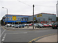
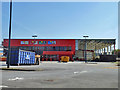
Hoo Hing, Mitcham
The oriental food specialists.
Image: © Robin Webster
Taken: 1 Apr 2012
0.10 miles
10
Raleigh Gardens, Mitcham
This small dead end was converted into a major part of the one way system.
Image: © David Howard
Taken: 31 Jan 2011
0.12 miles