IMAGES TAKEN NEAR TO
Addiscombe Road, CROYDON, CR0 6SP
Introduction
This page details the photographs taken nearby to Addiscombe Road, CR0 6SP by members of the Geograph project.
The Geograph project started in 2005 with the aim of publishing, organising and preserving representative images for every square kilometre of Great Britain, Ireland and the Isle of Man.

There are currently over 7.5m images from over14,400 individuals and you can help contribute to the project by visiting https://www.geograph.org.uk
Image Map
Images are licensed for reuse under creativecommons.org/licenses/by-sa/2.0
Notes
- Clicking on the map will re-center to the selected point.
- The higher the marker number, the further away the image location is from the centre of the postcode.
Image Listing (178 Images Found)
Images are licensed for reuse under creativecommons.org/licenses/by-sa/2.0
Image
Details
Distance
1
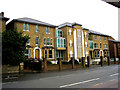
Croydon: South London Jamatkhana
Three large houses have been used to form this building: part of these was formerly used as a private school. The Jamatkhana is, as I understand it, a centre for the study of Ismaili, which is a sect of Islam led by the Aga Khan. It is on Addiscombe Road, should you wish to visit it, just opposite the Sandilands tram stop.
Image: © Dr Neil Clifton
Taken: 24 Feb 2010
0.01 miles
2
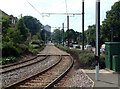
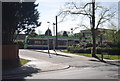
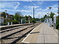
Looking west from Sandilands tramstop, Croydon
The Tramlink stop at Sandilands is where the branch from New Addington meets the line from Beckenham and Elmers End, both occupying part of the former railway line that terminated at Selsdon. The picture shows new line, towards Croydon. A tram is approaching, and the "threepenny bit building", as it is known locally (actually the NLA Tower) is in the background.
Image: © Philip Talmage
Taken: 2 Aug 2005
0.01 miles
3
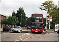
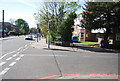
Addiscombe Road, Croydon
Looking east at the Sandilands bus stop, an Arriva DLA en route to West Croydon has just runfrom Lower Sydenham. The Sandilands tram stop is just off camera to the right.
Image: © Dr Neil Clifton
Taken: 13 Sep 2006
0.02 miles
4
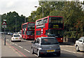
Addiscombe Road, Croydon
Looking west, just opposite the Sandilands tram stop. An Arriva 'DLA' is en route for Lower Sydenham, while behind it is a Metrobus on Route 119 to Bromley.
Image: © Dr Neil Clifton
Taken: 13 Sep 2006
0.02 miles
5
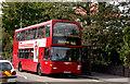
Croydon: Sandilands bus stop, eastbound
A Metrobus on Route 466, bound for Addington Village, calls at the Sandilands stop. This route starts from Caterham-on-the-Hill, Westway Common.
Image: © Dr Neil Clifton
Taken: 13 Sep 2006
0.02 miles
6
Sandilands Tramlink stop
Sandilands Tramlink stop is served by all three Tramlink routes. The area of Sandilands tram stop was one of the few places where property demolition was needed during the construction of Tramlink. This was necessary to make way for both the stop and the cutting link to the junction with the trackbed of the former Woodside and South Croydon Railway to the east where the route to New Addington diverges from those to Beckenham Junction and Elmers End.
Image: © Marathon
Taken: 25 Jul 2011
0.02 miles
7
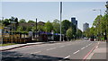
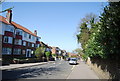
Croydon
Looking towards central Croydon, along Addiscombe Road, from beside the Sandilands tram stop.
Image: © Peter Trimming
Taken: 21 Apr 2020
0.03 miles