IMAGES TAKEN NEAR TO
Caroline Close, CROYDON, CR0 5JU
Introduction
This page details the photographs taken nearby to Caroline Close, CR0 5JU by members of the Geograph project.
The Geograph project started in 2005 with the aim of publishing, organising and preserving representative images for every square kilometre of Great Britain, Ireland and the Isle of Man.

There are currently over 7.5m images from over14,400 individuals and you can help contribute to the project by visiting https://www.geograph.org.uk
Image Map
Images are licensed for reuse under creativecommons.org/licenses/by-sa/2.0
Notes
- Clicking on the map will re-center to the selected point.
- The higher the marker number, the further away the image location is from the centre of the postcode.
Image Listing (82 Images Found)
Images are licensed for reuse under creativecommons.org/licenses/by-sa/2.0
Image
Details
Distance
3
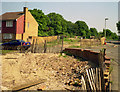
Larcombe Close, Croydon
New homes which had never been occupied had to be demolished here, to make way for the new tram system being introduced in Croydon.
Image: © Dr Neil Clifton
Taken: Unknown
0.10 miles

5
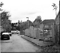
Demolition in Larcombe Close, Croydon
When the Woodside to Sanderstead railway closed at the end of September 1983, the trackbed, no longer required by British Railways, was put on sale and a nice plot near the site of Coombe Road station was acquired by a group of developers, who built some very nice bijou dwellings on it. Sadly the developers had not kept their eyes on the plans being drawn up for Croydon Tramlink, and some of the bijou dwellings had to be demolished before they had ever been lived in.
Image: © Dr Neil Clifton
Taken: 13 Nov 1997
0.10 miles
6
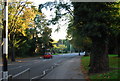
Stanhope Road, Croydon
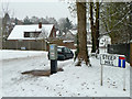
Steep Hill is the name of a residential road off to the right, which is unlikely to be as steep as this stretch of Stanhope Road. Nothing special normally, but in this weather ...
Image: © Robin Webster
Taken: 19 Dec 2010
0.10 miles
7
Tramlink
Tram passing Larcombe Close, on the approach to Lloyd Park.
Image: © Peter Trimming
Taken: 15 Jan 2021
0.11 miles
9

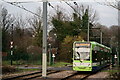
Tramlink
New Addington service, approaching the Larcombe Close crossing, on a very foggy afternoon.
Image: © Peter Trimming
Taken: 19 Dec 2021
0.11 miles
10
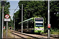
Tramlink
Tram approaching a crossing, prior to the turn into Lloyd Park. Tramlink utilises the trackbed of the former railway line to Woodside. Note the distant tunnel, which is several hundred yards long.
Image: © Peter Trimming
Taken: 31 May 2020
0.11 miles