IMAGES TAKEN NEAR TO
Riverside Mews, Bridle Path, CROYDON, CR0 4AQ
Introduction
This page details the photographs taken nearby to Riverside Mews, Bridle Path, CR0 4AQ by members of the Geograph project.
The Geograph project started in 2005 with the aim of publishing, organising and preserving representative images for every square kilometre of Great Britain, Ireland and the Isle of Man.

There are currently over 7.5m images from over14,400 individuals and you can help contribute to the project by visiting https://www.geograph.org.uk
Image Map
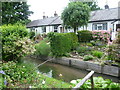
Images are licensed for reuse under creativecommons.org/licenses/by-sa/2.0
Notes
- Clicking on the map will re-center to the selected point.
- The higher the marker number, the further away the image location is from the centre of the postcode.
Image Listing (143 Images Found)
Images are licensed for reuse under creativecommons.org/licenses/by-sa/2.0
Image
Details
Distance
1
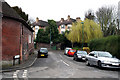
Beddington: Bridges Lane
Looking west from Wandle Mill. Bridges Lane bends round to the north and runs to a junction with Croydon Road near the 'Plough'.
Image: © Dr Neil Clifton
Taken: 29 Mar 2010
0.01 miles
2
Beddington: Wandle Road
Looking south from its junction with Richmond Road
Image: © Dr Neil Clifton
Taken: 29 Mar 2010
0.02 miles
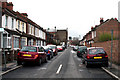
3
Beddington: Junction of Wandle Road with Bridle Path
Notices on the house wall above the second car indicate where Wandle Road (to the left) meets Bridle Road (to the right). So, of these four houses, only the right-hand one, which is named 'Bridle House', is in Bridle Path, the left-hand three being part of Wandle Road. The photograph was taken from the end of Bridges Lane.
Image: © Dr Neil Clifton
Taken: 29 Mar 2010
0.02 miles
4
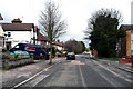
Beddington: Bridges Lane
Looking north from outside No 35. At the far end the road bends round to the east.
Image: © Dr Neil Clifton
Taken: 29 Mar 2010
0.02 miles
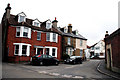
5
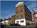
Wandle Mill
This building is on Wandle Road. It straddles the river of the same name. As one of the few intact former mill buildings along the river, I am surprised that it appears not to be listed. A photo on Flickr from 2009 shows it to be in use by a clutch manufacturer, but as of 2012 it appeared disused. On this site see also Image and Image
Image: © Stephen Craven
Taken: 19 Aug 2012
0.02 miles
6
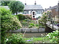
Mount Pleasant, Waddon
The delightful row of wooden cottages known as Mount Pleasant are accessed off Bridges Lane across the infant River Wandle via this small footbridge. They were originally built for the workers at the nearby former Beddington Mill. This was a manorial mill dating back to Domesday, grinding corn for much of its working life but converted to Lambert's Snuff Mill for most of the 18th and 19th centuries - see http://www.geograph.org.uk/photo/1767182
Image: © Marathon
Taken: 13 Jun 2012
0.02 miles
7
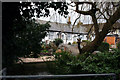
Beddington: Mount Pleasant Cottages
The River Wandle runs right in front of these three cottages, which have individual footbridges to the road.
Image: © Dr Neil Clifton
Taken: 22 Mar 2010
0.02 miles
8
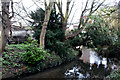
Beddington: River Wandle
Looking upstream, (east) just below the Mount Pleasant cottages. A boat can be seen up on the bank to the left. I assume its owner does not intend to use it to navigate the Wandle.
Image: © Dr Neil Clifton
Taken: 22 Mar 2010
0.02 miles
9
Cottages at Mount Pleasant, Waddon
The delightful row of wooden cottages known as Mount Pleasant are accessed off Bridges Lane across the infant River Wandle via a small footbridge. They were originally built for the workers at the nearby former Beddington Mill. This was a manorial mill dating back to Domesday, grinding corn for much of its working life but converted to Lambert's Snuff Mill for most of the 18th and 19th centuries - see http://www.geograph.org.uk/photo/1767182
Image: © Marathon
Taken: 13 Jun 2012
0.03 miles
10
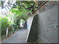
Buttressed wall
The wall runs along the back of housing on Wandle Court Gardens. The path is part of the Wandle Trail and links Hilliers Lane to Bridges Lane.
Image: © Stephen Craven
Taken: 19 Aug 2012
0.03 miles