IMAGES TAKEN NEAR TO
Newman Road, CROYDON, CR0 3JX
Introduction
This page details the photographs taken nearby to Newman Road, CR0 3JX by members of the Geograph project.
The Geograph project started in 2005 with the aim of publishing, organising and preserving representative images for every square kilometre of Great Britain, Ireland and the Isle of Man.

There are currently over 7.5m images from over14,400 individuals and you can help contribute to the project by visiting https://www.geograph.org.uk
Image Map
Images are licensed for reuse under creativecommons.org/licenses/by-sa/2.0
Notes
- Clicking on the map will re-center to the selected point.
- The higher the marker number, the further away the image location is from the centre of the postcode.
Image Listing (63 Images Found)
Images are licensed for reuse under creativecommons.org/licenses/by-sa/2.0
Image
Details
Distance
1
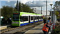
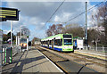
Ampere Way Tram Stop
As trams pass by, the tram stop receives a new coat of silver paint.
Image: © Peter Trimming
Taken: 27 Oct 2008
0.05 miles
2
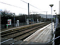
Croydon: Ampere Way tram stop
Looking east. This stop is on the line to Wimbledon, which follows the former railway alignment, and here, also follows the alignment of the horse-drawn Surrey Iron Railway.
Image: © Dr Neil Clifton
Taken: 15 Feb 2010
0.06 miles
3
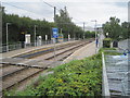
Ampere Way tram stop, Greater London
Opened in 2000 by Tramlink on the line from Croydon to Wimbledon.
View south east towards Waddon Marsh and Croydon. This was formerly the London Brighton & South Coast railway line, also from Croydon to Wimbledon.
Image: © Nigel Thompson
Taken: 10 Aug 2017
0.06 miles
4
Ampere Way Tram Stop
A new station on an old route, this was originally a conventional line built by the London, Brighton & South Coast Railway. It was converted to a tramway with many new stops, including here, which takes its name from one of the nearby streets with electrical names commemorating a large power station which used to be nearby.
The Wikipedia entry for this stop https://en.wikipedia.org/wiki/Ampere_Way_tram_stop is brief but contains the following trivia snippet.
"The station was renamed IKEA Ampere Way under a sponsorship deal on 18 October 2006, in order to promote the stop's location near IKEA's Croydon store. By March 2008, the station had reverted to its former name."
Image: © Des Blenkinsopp
Taken: 11 Feb 2020
0.07 miles
5

Ampere Way near Croydon
The Ampere Way tram stop on Croydon's Tramlink system. The system opened in 2000. Ampere Way is on a section of route which was previously a suburban railway line, although there was never a station here.
In the background, the chimneys are a reminder of an electricity generating station which stood here. Note that "ampere" is a unit of electric current.
Image: © Malc McDonald
Taken: 16 Jul 2011
0.08 miles
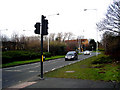
6
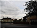
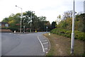
Purley Way at the corner of Fairmead Road
Image: © David Howard
Taken: 7 Oct 2012
0.08 miles
8
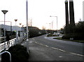
Croydon: Ampere Way, looking southeast
The two huge chimneys, remaining from the erstwhile Croydon B power station, are retained as advertisement for the nearby IKEA store.
Image: © Dr Neil Clifton
Taken: 15 Feb 2010
0.09 miles
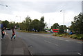
9
Croydon: Ampere Way, looking northwest
This is a very industrial area of Croydon, but an attempt has been made to make it more attractive by landscaping.
Image: © Dr Neil Clifton
Taken: 15 Feb 2010
0.10 miles