IMAGES TAKEN NEAR TO
Bowdens Lane, COLCHESTER, CO6 3BA
Introduction
This page details the photographs taken nearby to Bowdens Lane, CO6 3BA by members of the Geograph project.
The Geograph project started in 2005 with the aim of publishing, organising and preserving representative images for every square kilometre of Great Britain, Ireland and the Isle of Man.

There are currently over 7.5m images from over14,400 individuals and you can help contribute to the project by visiting https://www.geograph.org.uk
Image Map
Images are licensed for reuse under creativecommons.org/licenses/by-sa/2.0
Notes
- Clicking on the map will re-center to the selected point.
- The higher the marker number, the further away the image location is from the centre of the postcode.
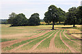
Image Listing (21 Images Found)
Images are licensed for reuse under creativecommons.org/licenses/by-sa/2.0
Image
Details
Distance
1
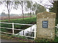
River Stour North of Wormingford
View of River Stour and Farmland North of Wormingford
Image: © David Sanderson
Taken: 18 Oct 2006
0.04 miles
2
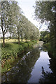
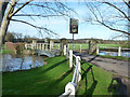
River Stour at Wormingford Bridge
Looking downstream from the road bridge; Suffolk is to the left and Essex to the right.
Image: © Bob Jones
Taken: 24 Jun 2008
0.05 miles
3
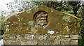
Old Bridge Marker on Wormingford Bridge, Mill Hill, Wormingford
Bridge Marker by the UC road, in parish of Wormingford (Colchester District), Mill Hill, Wormingford Bridge, River Stour, carved stone at top of Southeast bridge pier.
Surveyed
Milestone Society National ID: EX_WORM01br
Image: © M Bardell
Taken: 23 Oct 2017
0.06 miles
4
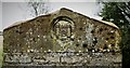
Old Bridge Marker by Wormingford Bridge over the River Stour
Bridge Marker by the UC road, Mill Hill in parish of Nayland With Wissington (Babergh District). Wormingford Bridge over River Stour, carved stone at top of bridge piers.
Surveyed
Milestone Society National ID: SU_NAYL01br.
Image: © Milestone Society
Taken: Unknown
0.06 miles
5
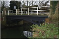
Wormingford Bridge
A modest cast iron bridge over the River Stour, dating from the 1870's. It is still in use today, albeit with a weight limit of 8 tonnes.
Image: © John Lemay
Taken: 1 Jan 2008
0.07 miles
6
Wormingford Bridge
Over a rather swollen River Stour. This is just downstream of the former mill. When the Stour was navigable, this loop of river and the mill were bypassed by a lock cut with two locks, somewhat further north.
Image: © Robin Webster
Taken: 13 Jan 2016
0.07 miles
7
Wormingford Bridge
The maps do not fib it is a "Smallbridge".
Image: © Glyn Baker
Taken: 29 Apr 2023
0.08 miles
8
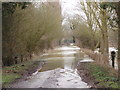
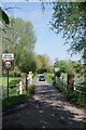
Flooded road
A view from the bridge at Mill Hill, Wormingford,Essex, over the flooding caused as the River Stour burst it banks after snow melt.
Image: © Peter Pearson
Taken: 11 Feb 2009
0.12 miles
9

River Stour at Wormingford Bridge
Looking upstream from the road bridge. The county border (Essex/Suffolk) follows the river.
Image: © Bob Jones
Taken: 24 Jun 2008
0.12 miles
10
Little Ash Field, Wormingford
An onion field to the east of the minor road between Wormingford and Smallbridge Hall.
Image: © Bob Jones
Taken: 24 Jun 2008
0.12 miles