IMAGES TAKEN NEAR TO
Cromwell Road, COLCHESTER, CO2 7EN
Introduction
This page details the photographs taken nearby to Cromwell Road, CO2 7EN by members of the Geograph project.
The Geograph project started in 2005 with the aim of publishing, organising and preserving representative images for every square kilometre of Great Britain, Ireland and the Isle of Man.

There are currently over 7.5m images from over14,400 individuals and you can help contribute to the project by visiting https://www.geograph.org.uk
Image Map
Images are licensed for reuse under creativecommons.org/licenses/by-sa/2.0
Notes
- Clicking on the map will re-center to the selected point.
- The higher the marker number, the further away the image location is from the centre of the postcode.
Image Listing (135 Images Found)
Images are licensed for reuse under creativecommons.org/licenses/by-sa/2.0
Image
Details
Distance
1
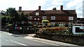
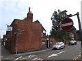
View of the former Winnocks Charity almshouses on Military Road #2
Looking south-southwest.
Image: © Robert Lamb
Taken: 16 Jul 2019
0.06 miles
3
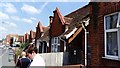
View of the former Winnocks Charity almshouses on Military Road
These almshouses are now bungalows. According to a plaque on the bungalow nearest the camera, the almshouses were built and funded by George Rose in 1933. Looking north-northwest.
Image: © Robert Lamb
Taken: 16 Jul 2019
0.08 miles
4

Mersea Road
To the left are the remains of the St John’s Abbey wall and to the right is an excellent watering hole the Odd One Out, purveyors of the finest real ale and cider. In former times this genuine free house was an Ind Coope establishment known as the Mermaid but that was more than twenty years ago.
Image: © Glyn Baker
Taken: 12 Aug 2009
0.08 miles
5
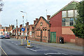
Old tram depot and almshouses, Military Road, Colchester
The nearer brick building (dated 1906) and the corrugated iron shed are the rear end of the old tram depot, whose front and tram access was on Magdalen Street. Beyond are almshouses, in the same style as the smaller buildings on the main site of Kendall's Almshouses, so presumably part of them, although isolated by the tram depot.
Image: © Robin Webster
Taken: 17 Jan 2016
0.08 miles
6
The Odd One Out, Mersea Road, Colchester
Formerly named "The Mermaid"
Image: © David Smith
Taken: 31 May 2017
0.09 miles
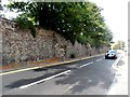
7
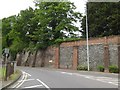
Retaining wall in Mersea Road, Colchester
The wall of the officers' club
Image: © David Smith
Taken: 31 May 2017
0.09 miles
8

Bus shelter and mixed wall, Mersea Road, Colchester
In the wall there is an assortment of materials, including a WD boundary marker
Image: © David Smith
Taken: 31 May 2017
0.10 miles
9
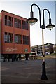
Colchester Magistrates Court
The newly opened Magistrates Courts in Colchester. They have been built on the old goods yard of Image that closed in the 1970's (if memory serves).
Image: © Glyn Baker
Taken: 5 Sep 2012
0.10 miles
10
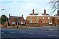
Kendall Almshouses, Colchester
Two identical large blocks, one and a part of the other visible here, and several smaller houses typified by the building on the left. The large blocks are grade II listed buildings, dated 1791 and 1803 for the one to the right. A detail of the inscription on the pediment for the 1791 building is here Image Rather oddly, the name of the Almshouses (at least for this block) does not correspond to the stated benefactor, Arthur Winsley. However, on older maps, before the smaller houses were built, the two big blocks are indeed called Winsley's Almshouses.
Image: © Robin Webster
Taken: 17 Jan 2016
0.10 miles