IMAGES TAKEN NEAR TO
The Heath, MANNINGTREE, CO11 2QJ
Introduction
This page details the photographs taken nearby to The Heath, CO11 2QJ by members of the Geograph project.
The Geograph project started in 2005 with the aim of publishing, organising and preserving representative images for every square kilometre of Great Britain, Ireland and the Isle of Man.

There are currently over 7.5m images from over14,400 individuals and you can help contribute to the project by visiting https://www.geograph.org.uk
Image Map
Images are licensed for reuse under creativecommons.org/licenses/by-sa/2.0
Notes
- Clicking on the map will re-center to the selected point.
- The higher the marker number, the further away the image location is from the centre of the postcode.
Image Listing (12 Images Found)
Images are licensed for reuse under creativecommons.org/licenses/by-sa/2.0
Image
Details
Distance

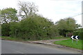
2

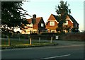
Mistley Heath
The small village of Mistley Heath, in north Essex.
Image: © Malc McDonald
Taken: 18 Jul 2015
0.06 miles
4
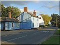
Heath Road, Mistley Heath
The blue building is part of the Blacksmith's Arms & Heath Motel
Image: © Roger Jones
Taken: 25 Jun 2011
0.07 miles
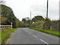
5
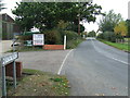
Heath Road
Heath Road at Mistley Heath, Essex.
Image: © Keith Evans
Taken: 11 Oct 2017
0.11 miles
6
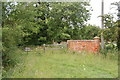
The Essex Way 148: remains of St Mary's church
Not much is left to be seen of the church - some gravestones and some foundations; also this gateway and section of churchyard wall.
Image: © Trevor Harris
Taken: 12 Jun 2011
0.14 miles
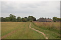
7
The Essex Way leading off Heath Road
In the hamlet of Mistley Heath
Image: © Tim Heaton
Taken: 16 Oct 2020
0.14 miles
8
The Essex Way 147: approaching Church Farm
A way marker indicating the footpath junction here as the Essex Way crosses a north-south footpath. Church Farm, named after St Mary's Church - a few remains of which can be seen - is in the background.
Image: © Trevor Harris
Taken: 12 Jun 2011
0.17 miles
9
Windmill Road, Mistley Heath
The Mistley, Thorpe and Walton Railway, abandoned before it was finished, was to have crossed the road just about on the bend ahead. Some maps suggest a bridge was built, road over railway, but there is no trace now.
Image: © Robin Webster
Taken: 30 Oct 2016
0.18 miles
10
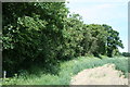
Mistley Thorpe and Walton railway
The Essex Way path crosses a twin hedge line with a shallow cutting between, running north-south. These earthworks are almost the only evidence of a railway that hardly got off the drawing board, planned in 1863 and abandoned in 1869.
Image: © John Lemay
Taken: 6 Jun 2014
0.20 miles