IMAGES TAKEN NEAR TO
Acre Walk, SUDBURY, CO10 8RG
Introduction
This page details the photographs taken nearby to Acre Walk, CO10 8RG by members of the Geograph project.
The Geograph project started in 2005 with the aim of publishing, organising and preserving representative images for every square kilometre of Great Britain, Ireland and the Isle of Man.

There are currently over 7.5m images from over14,400 individuals and you can help contribute to the project by visiting https://www.geograph.org.uk
Image Map
Images are licensed for reuse under creativecommons.org/licenses/by-sa/2.0
Notes
- Clicking on the map will re-center to the selected point.
- The higher the marker number, the further away the image location is from the centre of the postcode.
Image Listing (37 Images Found)
Images are licensed for reuse under creativecommons.org/licenses/by-sa/2.0
Image
Details
Distance
1
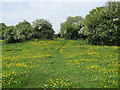
Buttercups on Clare Camp
The buttercups brighten up this view of parts of Clare Camp http://en.wikipedia.org/wiki/Clare_Camp part of Clare Common.
Image: © Roger Jones
Taken: 4 May 2014
0.10 miles
2
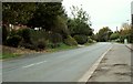
The B.1063 at Clare, Suffolk
The green sign on the far right, marks the entrance to Hermitage Farm.
Image: © Robert Edwards
Taken: 30 Oct 2006
0.11 miles
3
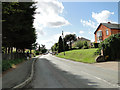
Where Snow Hill becomes Bridewell Street, Clare
Image: © Adrian S Pye
Taken: 28 Aug 2015
0.14 miles
4
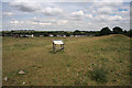
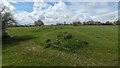
Clare Common
Clare Common is an important archaeological site; the large ditches and banks are probably the defences of an Iron Age site known as Clare Camp, built more than 2,000 years ago. Much of the D-shaped earthwork is still clearly visible, although erosion and later alterations have reduced the size of the banks.
About 700 years ago, the medieval manor of Erbury (taking its name from this 'earth-burh' or earth fort) stood within this site. Some outlines on the ground suggest the sites of at least two large buildings, with courtyards. Medieval documents suggest that there were barns, a dovehouse, a granary and servants' quarters.
In the early 1500s, Katherine of Aragon gave this land to be a common pasture for the poor to graze their cattle on. The Lower Common has been grazed ever since.
Image: © Bob Jones
Taken: 8 Jul 2010
0.14 miles
5
![Clare houses [28]](https://s0.geograph.org.uk/geophotos/06/75/52/6755256_ffa8e832_120x120.jpg)
Clare houses [28]
Numbers 30 to 34 Bridewell Street occupy one large house. There is a 15th century timber framed and plastered house facing the street which became three cottages (numbers 32, 33 and 34) and is now one house which has been renovated - number 33. There is a 16th century crosswing, timber framed and plastered, jettied to the street with exposed framing in which are numbers 30 and 31. Listed, grade II, with details at: https://historicengland.org.uk/listing/the-list/list-entry/1194265
The market town of Clare is Suffolk’s smallest town. It lies on the north bank of the River Stour some 12 miles south of Bury St Edmunds and some 7 miles west of Sudbury. Remains of every period since the Palaeolithic have been found in the area. There is a Norman castle, a 13th century Augustinian Priory and a fine, medieval ‘wool’ church as well as many listed buildings, some of which date to the 16th century or earlier.
Image: © Michael Dibb
Taken: 14 Sep 2020
0.18 miles
6
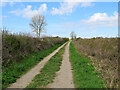
Clare: Sheepgate Lane
A track which skirts the Upper Common, photographed on a sunny spring morning.
Image: © John Sutton
Taken: 13 Apr 2021
0.18 miles
7
Rampart and Ditch at Clare Camp
https://historicengland.org.uk/listing/the-list/list-entry/1006046?section=official-list-entry
Image: © Sandy Gerrard
Taken: 14 Apr 2023
0.19 miles
8
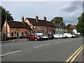
Cottages and inns in Bridewell Street, Clare
The Cock Inn (left foreground) may date from the 15th century but the first reference to it as an inn is in 1636. Part of the building was used as a schoolroom for a few years from 1834. It was renovated in the 20th century. The premises now in use combine half the original inn with a converted barn. The doorway has an 18th century doorcase. 17th century records include mention of surveyors being fined 'for a Rail lying open to the Cock Ditch' at the rear of the inn. A 17th century house adjoining it was originally part of the inn. The adjoining Peterhouse dates from the 17th century and has an early C19 shop window. The house has a purple pig painted on it which children touch ‘for luck’ on their way to school. The pig is also a reminder that this house achieved national fame in the early 21st century when it was painted purple, which some alleged was not a suitable colour for the area. The dispute nearly reached the European Court but a local builder provided a special tone of pink paint to bring it more into line with tradition. The pig was left as a reminder of this piece of history. It is adjoined by an 18th century range of houses and finally the Globe Inn, dating from 1695. It was re-fronted in white brick early in the 19th century and has a hipped roof. This information was taken from "A historical look at Clare" by David Hatton which is available on the Internet in pdf-format: http://www.clare-uk.com/pages/hatton-book-681.htm.
Clare is situated on the A1092 road, about 8 miles from Sudbury and 8 miles from Haverhill. Clare once was a border fortress town between the kingdom of the East Angles and the Saxons and its name is believed to be derived from the Roman word Clarus, meaning illustrious or renowned. Clare is mentioned in the Domesday Book as a settlement of 600 inhabitants, with extensive vineyards. The latter no longer exist but it is possible that Claret got its name from Clare. A castle was built after the Battle of Hastings in 1066 in order to protect the surrounding land and its ruined castle's stone keep > http://www.geograph.org.uk/photo/2072116 remains until today. It is situated on the edge of Clare Country Park > http://www.geograph.org.uk/photo/2072118 and can be accessed via a footpath around the motte. The Country Park also houses the disused Clare railway station > http://www.geograph.org.uk/photo/2072125 and a goods shed > http://www.geograph.org.uk/photo/2072119 which is now the park's visitor centre. Austian Friars arrived in the town in 1249 and were given land here. They built a Friars House and the church > http://www.geograph.org.uk/photo/2072712. The town has many historic houses > http://www.geograph.org.uk/photo/2072565 and buildings, with Clare Ancient House > http://www.geograph.org.uk/photo/2072752 being one of the oldest houses in Suffolk. It became the town museum in 1979 and is notable for its superb plasterwork which is an outstanding work of the local craft of pargetting > http://www.geograph.org.uk/photo/2072761 that is still practised today. This decorated plaster-work can be seen on a number of houses, much of it done on old timber-framed buildings. While the plaster is still wet it is either worked over with wooden combs to produce herringbone, shell and similar patterns or shapes are applied with moulds or sculpted by hand to create more individuality.
Image: © Evelyn Simak
Taken: 18 Sep 2010
0.19 miles
9
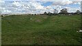
Clare Camp Rampart and Ditch
https://historicengland.org.uk/listing/the-list/list-entry/1006046?section=official-list-entry
Image: © Sandy Gerrard
Taken: 14 Apr 2023
0.19 miles
10
![Clare houses [29]](https://s3.geograph.org.uk/geophotos/06/75/52/6755259_b7c4be5c_120x120.jpg)
Clare houses [29]
Number 37 Bridewell Street was originally a pair of cottages, now one property. Early 19th century, timber framed and plastered. There is a small 19th century shop window on the right. Listed, grade II, with details at: https://historicengland.org.uk/listing/the-list/list-entry/1031768
The market town of Clare is Suffolk’s smallest town. It lies on the north bank of the River Stour some 12 miles south of Bury St Edmunds and some 7 miles west of Sudbury. Remains of every period since the Palaeolithic have been found in the area. There is a Norman castle, a 13th century Augustinian Priory and a fine, medieval ‘wool’ church as well as many listed buildings, some of which date to the 16th century or earlier.
Image: © Michael Dibb
Taken: 14 Sep 2020
0.19 miles