Cottages and inns in Bridewell Street, Clare
Introduction
The photograph on this page of Cottages and inns in Bridewell Street, Clare by Evelyn Simak as part of the Geograph project.
The Geograph project started in 2005 with the aim of publishing, organising and preserving representative images for every square kilometre of Great Britain, Ireland and the Isle of Man.

There are currently over 7.5m images from over 14,400 individuals and you can help contribute to the project by visiting https://www.geograph.org.uk
Cottages and inns in Bridewell Street, Clare
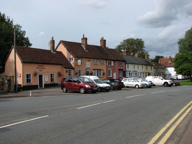
Image: © Evelyn Simak Taken: 18 Sep 2010
The Cock Inn (left foreground) may date from the 15th century but the first reference to it as an inn is in 1636. Part of the building was used as a schoolroom for a few years from 1834. It was renovated in the 20th century. The premises now in use combine half the original inn with a converted barn. The doorway has an 18th century doorcase. 17th century records include mention of surveyors being fined 'for a Rail lying open to the Cock Ditch' at the rear of the inn. A 17th century house adjoining it was originally part of the inn. The adjoining Peterhouse dates from the 17th century and has an early C19 shop window. The house has a purple pig painted on it which children touch ‘for luck’ on their way to school. The pig is also a reminder that this house achieved national fame in the early 21st century when it was painted purple, which some alleged was not a suitable colour for the area. The dispute nearly reached the European Court but a local builder provided a special tone of pink paint to bring it more into line with tradition. The pig was left as a reminder of this piece of history. It is adjoined by an 18th century range of houses and finally the Globe Inn, dating from 1695. It was re-fronted in white brick early in the 19th century and has a hipped roof. This information was taken from "A historical look at Clare" by David Hatton which is available on the Internet in pdf-format: http://www.clare-uk.com/pages/hatton-book-681.htm. Clare is situated on the A1092 road, about 8 miles from Sudbury and 8 miles from Haverhill. Clare once was a border fortress town between the kingdom of the East Angles and the Saxons and its name is believed to be derived from the Roman word Clarus, meaning illustrious or renowned. Clare is mentioned in the Domesday Book as a settlement of 600 inhabitants, with extensive vineyards. The latter no longer exist but it is possible that Claret got its name from Clare. A castle was built after the Battle of Hastings in 1066 in order to protect the surrounding land and its ruined castle's stone keep > http://www.geograph.org.uk/photo/2072116 remains until today. It is situated on the edge of Clare Country Park > http://www.geograph.org.uk/photo/2072118 and can be accessed via a footpath around the motte. The Country Park also houses the disused Clare railway station > http://www.geograph.org.uk/photo/2072125 and a goods shed > http://www.geograph.org.uk/photo/2072119 which is now the park's visitor centre. Austian Friars arrived in the town in 1249 and were given land here. They built a Friars House and the church > http://www.geograph.org.uk/photo/2072712. The town has many historic houses > http://www.geograph.org.uk/photo/2072565 and buildings, with Clare Ancient House > http://www.geograph.org.uk/photo/2072752 being one of the oldest houses in Suffolk. It became the town museum in 1979 and is notable for its superb plasterwork which is an outstanding work of the local craft of pargetting > http://www.geograph.org.uk/photo/2072761 that is still practised today. This decorated plaster-work can be seen on a number of houses, much of it done on old timber-framed buildings. While the plaster is still wet it is either worked over with wooden combs to produce herringbone, shell and similar patterns or shapes are applied with moulds or sculpted by hand to create more individuality.
Images are licensed for reuse under creativecommons.org/licenses/by-sa/2.0
Image Location
Latitude
52.082092
Longitude
0.580996