Clare houses [28]
Introduction
The photograph on this page of Clare houses [28] by Michael Dibb as part of the Geograph project.
The Geograph project started in 2005 with the aim of publishing, organising and preserving representative images for every square kilometre of Great Britain, Ireland and the Isle of Man.

There are currently over 7.5m images from over 14,400 individuals and you can help contribute to the project by visiting https://www.geograph.org.uk
Clare houses [28]
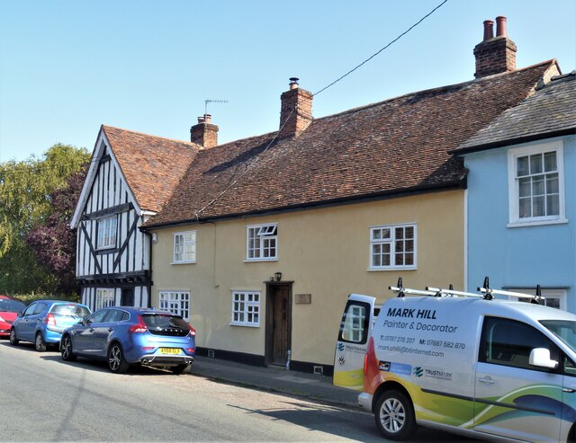
Image: © Michael Dibb Taken: 14 Sep 2020
Numbers 30 to 34 Bridewell Street occupy one large house. There is a 15th century timber framed and plastered house facing the street which became three cottages (numbers 32, 33 and 34) and is now one house which has been renovated - number 33. There is a 16th century crosswing, timber framed and plastered, jettied to the street with exposed framing in which are numbers 30 and 31. Listed, grade II, with details at: https://historicengland.org.uk/listing/the-list/list-entry/1194265 The market town of Clare is Suffolk’s smallest town. It lies on the north bank of the River Stour some 12 miles south of Bury St Edmunds and some 7 miles west of Sudbury. Remains of every period since the Palaeolithic have been found in the area. There is a Norman castle, a 13th century Augustinian Priory and a fine, medieval ‘wool’ church as well as many listed buildings, some of which date to the 16th century or earlier.
Images are licensed for reuse under creativecommons.org/licenses/by-sa/2.0
Image Location
Latitude
52.082608
Longitude
0.582048