IMAGES TAKEN NEAR TO
Blue Mill Lane, MALDON, CM9 6LS
Introduction
This page details the photographs taken nearby to Blue Mill Lane, CM9 6LS by members of the Geograph project.
The Geograph project started in 2005 with the aim of publishing, organising and preserving representative images for every square kilometre of Great Britain, Ireland and the Isle of Man.

There are currently over 7.5m images from over14,400 individuals and you can help contribute to the project by visiting https://www.geograph.org.uk
Image Map
Images are licensed for reuse under creativecommons.org/licenses/by-sa/2.0
Notes
- Clicking on the map will re-center to the selected point.
- The higher the marker number, the further away the image location is from the centre of the postcode.
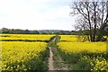
Image Listing (10 Images Found)
Images are licensed for reuse under creativecommons.org/licenses/by-sa/2.0
Image
Details
Distance
2
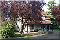
The Cats, Woodham Walter
Rather unusual pub hidden away to the north of the village.
Image: © John Myers
Taken: 1 Sep 2006
0.06 miles
3
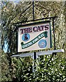
The Cats - Pub sign
Unusual pub - unusual sign.
Image: © John Myers
Taken: 1 Sep 2006
0.06 miles
4
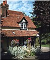
A view of Blue Mill from Blue Mill Lane
This now stands as a very nice mill conversion.
Image: © Robert Edwards
Taken: 21 Mar 2008
0.12 miles
5
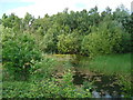
Disused Pit, nr Blue Mill Lane, Woodham Walter
Water and Nature seem to have successfully colonised this old pit, South of Blue Mill Lane, Woodham Walter
Image: © Roger Jones
Taken: 21 May 2011
0.17 miles
6
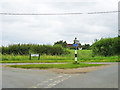
Triangle at the junction
Hop Garden Lane, Blue Mill Lane and Curling Tye Lane meet here.
Image: © Robin Webster
Taken: 24 Jun 2013
0.20 miles
7
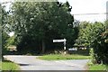
Road Junction
The junction of Hop Gardens Lane with Curling Tye Lane and Blue Mill Lane. The track beyond the gate on the left leads to Whitehouse Farm.
Image: © Paul Franks
Taken: 17 Aug 2018
0.20 miles
8
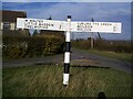
Direction Sign ? Signpost in Woodham Walter
Located on a grass triangle in the centre of the junction of Blue Mill Lane, Curling Tye Lane and Hop Garden Lane in Woodham Walter parish. 2 arms and missing finial. See also https://www.geograph.org.uk/photo/5880154.
Milestone Society National ID: EX_TL8107
Image: © John V Nicholls
Taken: 31 Oct 2002
0.20 miles
9

House near Curling Tye Green
Once a row of four cottages, this is now a single house.
Image: © Trevor Harris
Taken: 21 Sep 2008
0.24 miles
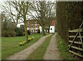
10
Footpath Junction Near Woodhouse Farm
Ahead for Woodham Walter left for Image, Right for Woodhouse Farm
Image: © Glyn Baker
Taken: 6 May 2016
0.24 miles