IMAGES TAKEN NEAR TO
Church Street, BRAINTREE, CM7 5GW
Introduction
This page details the photographs taken nearby to Church Street, CM7 5GW by members of the Geograph project.
The Geograph project started in 2005 with the aim of publishing, organising and preserving representative images for every square kilometre of Great Britain, Ireland and the Isle of Man.

There are currently over 7.5m images from over14,400 individuals and you can help contribute to the project by visiting https://www.geograph.org.uk
Image Map
Images are licensed for reuse under creativecommons.org/licenses/by-sa/2.0
Notes
- Clicking on the map will re-center to the selected point.
- The higher the marker number, the further away the image location is from the centre of the postcode.
Image Listing (36 Images Found)
Images are licensed for reuse under creativecommons.org/licenses/by-sa/2.0
Image
Details
Distance
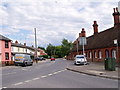
1
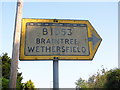
Pre-Worboys sign, Bocking Church Street
Yellow bordered arrows were used in urban areas and sometimes elsewhere like this suburban example. The dotted line above the road number means 'leading to' the B1053.
Image: © David Howard
Taken: 6 Jun 2013
0.01 miles
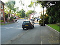
2
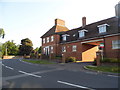
Small housing development on Church Street
Image: © David Howard
Taken: 6 Jun 2013
0.02 miles
3
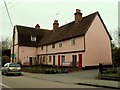
Old House, Bocking Churchstreet, Essex
This is one of the many listed buildings that make up the fine village of Bocking, near Braintree. A plaque on the side of the house dates it as 1500. It was probably one house when it was first built but it now appears to be split into five homes.
Image: © Robert Edwards
Taken: 19 Mar 2006
0.02 miles
4
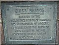
Old Bridge Marker on Kings' Bridge, Bocking Churchstreet
Bridge Marker by the UC road, in parish of Braintree (Braintree District), Kings' Bridge, Church Lane, Braintree.
Inscription reads:-
KINGS' BRIDGE
-------------
ERECTED BY THE
RURAL DISTRICT COUNCIL OF BRAINTREE
AND PARISHIONERS OF BOCKING
TO COMMEMORATE THE REIGN OF
KING EDWARD VII. AND THE
CORONATION OF KING GEORGE V.
ANNO DOMINI 1914.
Surveyed
Milestone Society National ID: EX_BRAIN01br
Image: © Milestone Society
Taken: Unknown
0.02 miles
6
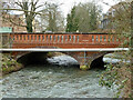
King's Bridge (Church Lane), Bocking Churchstreet
Looking upstream. This may be where the River Pant changes its name to River Blackwater on its way to the sea.
Image: © Robin Webster
Taken: 19 Mar 2013
0.02 miles
7
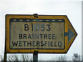
Old direction sign, Bocking Churchstreet
On a road leading to the B1053, as indicated by the chequered top margin. The two destinations are in opposite directions once the B1053 is reached.
Image: © Robin Webster
Taken: 19 Mar 2013
0.02 miles
8
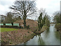
River Pant, Bocking Churchstreet, 2013
Looking upstream from King's Bridge (Church Lane). On the left the pile of rubble is where there was an industrial site. It is now built over with housing.
Image: © Robin Webster
Taken: 19 Mar 2013
0.03 miles
10
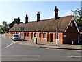
Royal Almshouses, Deans Walk, Bocking Churchstreet
Image: © PAUL FARMER
Taken: 18 Sep 2011
0.04 miles