IMAGES TAKEN NEAR TO
Chelmsford Road, CHELMSFORD, CM3 1AW
Introduction
This page details the photographs taken nearby to Chelmsford Road, CM3 1AW by members of the Geograph project.
The Geograph project started in 2005 with the aim of publishing, organising and preserving representative images for every square kilometre of Great Britain, Ireland and the Isle of Man.

There are currently over 7.5m images from over14,400 individuals and you can help contribute to the project by visiting https://www.geograph.org.uk
Image Map
Images are licensed for reuse under creativecommons.org/licenses/by-sa/2.0
Notes
- Clicking on the map will re-center to the selected point.
- The higher the marker number, the further away the image location is from the centre of the postcode.
Image Listing (7 Images Found)
Images are licensed for reuse under creativecommons.org/licenses/by-sa/2.0
Image
Details
Distance
2
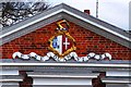
Arms of Tufnell and Cressener
Displayed under the pediment of the Image Samuel Tufnell and his wife Elizabeth Cressener built the house around 1719, and the motto is that of the Tufnells "Esse quam videri", which may be rendered "To be rather than to seem".
Image: © Tiger
Taken: 1 Apr 2013
0.17 miles
3
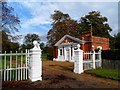
Lodge house to the Langleys
Built around the same time as the house (see http://www.geograph.org.uk/photo/3375546 i.e. around 1719). See http://www.geograph.org.uk/photo/3636021 for an explanation of the coat of arms.
Image: © Bikeboy
Taken: 11 Oct 2014
0.17 miles
4
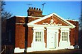
South Lodge to Langleys
The lodge at the entrance to the park on the Chelmsford Road was built around 1719 by Samuel Tufnell, the new owner of the property, and his wife Elizabeth Cressener, As Pevsner points out, the pedimented design displaying the Image imitates the main house Image in miniature. Compare with the much simpler Image
An anachronistic note, jarring with this early Georgian elegance, is struck by the two aerials on the roof: on the left, Band II (for VHF radio), apparently aligned with the Wrotham transmitter in Kent, and to the right a UHF TV aerial probably looking at Crystal Palace. In a more recent view Image these have been removed and only a discreet flagpole (or perhaps a disguised digital antenna?) rises from the roofline.
Image: © Tiger
Taken: 26 Dec 1978
0.17 miles
5
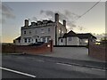
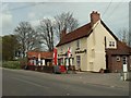
Large house on Chelmsford Road, Minnow End
Minnow End is the hamlet between Great Waltham and Little Waltham
Image: © David Howard
Taken: 31 Oct 2021
0.20 miles
7
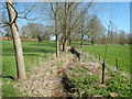
Walthambury Brook
The brook flows through Langleys Park. This view is looking downstream from the public footpath through the park, about 750 metres above its confluence with the River Chelmer.
Image: © Paul Franks
Taken: 20 Apr 2013
0.24 miles