IMAGES TAKEN NEAR TO
Burtons Mill, Mill Lane, SAWBRIDGEWORTH, CM21 9PL
Introduction
This page details the photographs taken nearby to Burtons Mill, Mill Lane, CM21 9PL by members of the Geograph project.
The Geograph project started in 2005 with the aim of publishing, organising and preserving representative images for every square kilometre of Great Britain, Ireland and the Isle of Man.

There are currently over 7.5m images from over14,400 individuals and you can help contribute to the project by visiting https://www.geograph.org.uk
Image Map
Images are licensed for reuse under creativecommons.org/licenses/by-sa/2.0
Notes
- Clicking on the map will re-center to the selected point.
- The higher the marker number, the further away the image location is from the centre of the postcode.
Image Listing (98 Images Found)
Images are licensed for reuse under creativecommons.org/licenses/by-sa/2.0
Image
Details
Distance
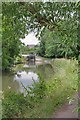
1
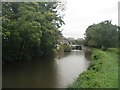
Stort Navigation Sawbridgeworth
View upstream towards lock 5.
Image: © David Leeming
Taken: 15 Sep 2013
0.03 miles
2
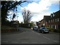
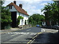
Leat Close, Sawbridgeworth
Off Station Road. Mill Lane bears off to the right behind the parked cars and leads down to the River Stort.
Image: © Richard Vince
Taken: 12 Mar 2022
0.04 miles
3
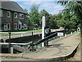
Lee and Stort Navigation: Lock no 5 - Sawbridgeworth Lock - close-up view
Image: © Peter S
Taken: 23 Sep 2016
0.05 miles
4
Lee and Stort Navigation: Lock no 5 - Sawbridgeworth Lock - looking north-west
Image: © Peter S
Taken: 23 Sep 2016
0.05 miles
5
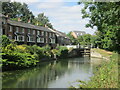
Sawbridgeworth Lock 5 on the Stort Navigation
Image: © David Leeming
Taken: 15 Sep 2013
0.05 miles
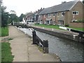
6
Sawbridgeworth Lock (5)
Looking Stortford bound on the navigation.
Image: © Glyn Baker
Taken: 7 Jul 2020
0.05 miles
7
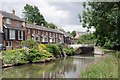
Lockside Living in Sawbridgeworth
A modern terrace beside Image
Image: © Glyn Baker
Taken: 7 Jul 2020
0.06 miles
8
Lee and Stort Navigation: Lock no 5 - Sawbridgeworth Lock
The route passes under a railway bridge (Kecksy's Bridge) and Sawbridgeworth is 3/4 of a mile from here as a sign indicates while Bishop's Stortford is 3 miles the other way. Despite its proximity to a town, this is another pretty lock, especially the view looking back at it from downstream.
Image: © Peter S
Taken: 23 Sep 2016
0.06 miles
9
Woodland at Sawbridgeworth railway station
The steeple of St Mary The Great church is visible on the horizon. The River Stort is amongst the trees.
Image: © Thomas Nugent
Taken: 19 Jun 2010
0.07 miles
10
Station Road
At the junction with Knight Street.
Image: © Thomas Nugent
Taken: 19 Jun 2010
0.07 miles