IMAGES TAKEN NEAR TO
Pastoral Way, BRENTWOOD, CM14 5GB
Introduction
This page details the photographs taken nearby to Pastoral Way, CM14 5GB by members of the Geograph project.
The Geograph project started in 2005 with the aim of publishing, organising and preserving representative images for every square kilometre of Great Britain, Ireland and the Isle of Man.

There are currently over 7.5m images from over14,400 individuals and you can help contribute to the project by visiting https://www.geograph.org.uk
Image Map
Images are licensed for reuse under creativecommons.org/licenses/by-sa/2.0
Notes
- Clicking on the map will re-center to the selected point.
- The higher the marker number, the further away the image location is from the centre of the postcode.
Image Listing (21 Images Found)
Images are licensed for reuse under creativecommons.org/licenses/by-sa/2.0
Image
Details
Distance
1
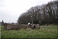
Holely Wood and Holly Wood
Holly Wood was named in 2008 by children from the Holly Trees Primary School it is now managed for nature by Brentwood Council it was formerly in the grounds of the Warley Hospital.
Image: © Glyn Baker
Taken: 6 Mar 2013
0.06 miles
2
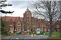
Former Administration Building, Warley Mental Hospital
The hospital - one of the largest mental hospitals in the country - is now closed; its grounds now houses a high-class estate, and its surviving buildings, like this block, have been converted into flats and apartments.
Image: © Trevor Harris
Taken: 27 Nov 2008
0.09 miles
3
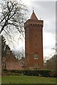
Water Tower, Warley
This impressive tower was the water tower which served the enormous Warley Mental Hospital, which is now a swish housing estate.
Image: © Trevor Harris
Taken: 27 Nov 2008
0.09 miles
4
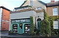
Picturesque gift shop on Warley Hill, Warley
Image: © David Howard
Taken: 29 Oct 2023
0.10 miles
5
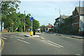
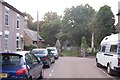
Junction of Warley Hill and Pastoral Way
Pastoral Way to the left was formerly the entrance to a large mental hospital, now converted to housing.
Image: © Robin Webster
Taken: 15 Sep 2011
0.10 miles
6
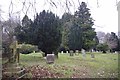
Lorne Rd Cemetery
This Brentwood Cemetery is now a Nature Reserve.
Image: © Glyn Baker
Taken: 6 Mar 2013
0.11 miles
7
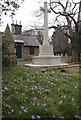
Brentwood Museum & War Memorial
The Sextons lodge in Image is now Brentwood Museum http://www.brentwoodmuseum.org.uk/Brentwood_Museum/Welcome.html
Image: © Glyn Baker
Taken: 6 Mar 2013
0.13 miles
8
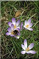
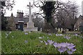
Bumblebee in Brentwood Cemetery
The first Bumblebee of 2013 (for me) feeding on the crocuses in Image
Image: © Glyn Baker
Taken: 6 Mar 2013
0.13 miles
9
Lorne Road Cemetery
The low building on the right, beyond the cemetery gates, is (or maybe was - as it appears to be boarded up) Brentwood Museum.
Image: © Trevor Harris
Taken: 4 Sep 2008
0.13 miles
10
The Old Brentwood Cemetery
In the background you can see the old sextons lodge now Brentwood Museum http://www.brentwoodmuseum.org.uk/Brentwood_Museum/Welcome.html the cemetery is now managed as a nature reserve.
Image: © Glyn Baker
Taken: 6 Mar 2013
0.13 miles