IMAGES TAKEN NEAR TO
Parkinson Drive, CHELMSFORD, CM1 3GW
Introduction
This page details the photographs taken nearby to Parkinson Drive, CM1 3GW by members of the Geograph project.
The Geograph project started in 2005 with the aim of publishing, organising and preserving representative images for every square kilometre of Great Britain, Ireland and the Isle of Man.

There are currently over 7.5m images from over14,400 individuals and you can help contribute to the project by visiting https://www.geograph.org.uk
Image Map (Loading...)


Getting Data...Please wait
Leaflet Map data © OpenStreetMap
Images are licensed for reuse under creativecommons.org/licenses/by-sa/2.0
Notes
- Clicking on the map will re-center to the selected point.
- The higher the marker number, the further away the image location is from the centre of the postcode.
Image Listing (22 Images Found)
Images are licensed for reuse under creativecommons.org/licenses/by-sa/2.0
Image
Details
Distance
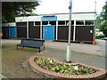
1
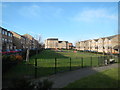
Rookes Crescent Play Area
An open space in the middle of 'The Village'
Image: © Paul Franks
Taken: 8 Feb 2013
0.08 miles
2
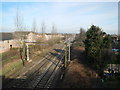
The London to Norwich Railway Line
Viewed from the Writtle Road bridge, in the direction of Chelmsford station. On the left is 'The Village', a housing development on the site of the Marconi Radar factory. In the far right distance can be seen the spire of Chelmsford Cathedral and the Essex County Cricket Club floodlights.
Image: © Paul Franks
Taken: 8 Feb 2013
0.14 miles
3
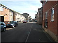
Evelyn Place
A typical street in 'The Village'.Many of the houses have no rear access for refuse collection, so wheelie bins have to be left outside the front doors. Beyond the mini roundabout (not immediately obvious in the photo), is Rookes Crescent (TL6905), which is not actually a crescent. The streets are named after Colonel Rookes Evelyn Bell Crompton, whose factory once stood on this site.
Image: © Paul Franks
Taken: 8 Feb 2013
0.16 miles
4
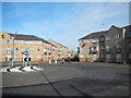
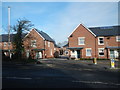
The Village
A development of private and social housing built on the site of Marconi Radar. Part of the site had been Crompton's Arc Works, later Crompton Parkinson, and roads in The Village are named after Crompton and Parkinson, but not Marconi. The road seen here, beyond the roundabout, is Parkinson Drive.
Image: © Paul Franks
Taken: 8 Feb 2013
0.17 miles
5
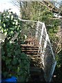
Derelict Steps
These steps were for pedestrian access to the Marconi Radar factory from Writtle Road bridge. They fell out of use several years before the factory itself closed.
Image: © Paul Franks
Taken: 8 Feb 2013
0.18 miles
6
The Cherry Tree Pub, Cherry Garden Lane
Another victim of the decrease in the pub trade
Image: © Nick Mutton 01329 000000
Taken: 27 Jun 2007
0.19 miles
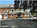
7
Royal British Legion (1925) Chelmsford
This is the Royal British Legion (1925) in Chelmsford on New London Road
Image: © Nick Mutton 01329 000000
Taken: 28 Jun 2007
0.19 miles
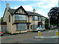
8
South Lodge Hotel, New London Road
This is South Lodge Hotel, 196 New London Road. Stayed at this hotel on 27th & 28th June 2007.
Image: © Nick Mutton 01329 000000
Taken: 27 Jun 2007
0.20 miles
9
Morello Mews
A new housing development on the site of the Cherry Tree pub.
Image: © Paul Franks
Taken: 8 Feb 2013
0.21 miles
10
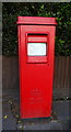
Elizabeth II postbox on New London Road, Chelmsford
Postbox No. CM2 59.
See Image] for context.
Image: © JThomas
Taken: 11 May 2019
0.21 miles