IMAGES TAKEN NEAR TO
New Road, HENGOED, CF82 8BG
Introduction
This page details the photographs taken nearby to New Road, CF82 8BG by members of the Geograph project.
The Geograph project started in 2005 with the aim of publishing, organising and preserving representative images for every square kilometre of Great Britain, Ireland and the Isle of Man.

There are currently over 7.5m images from over14,400 individuals and you can help contribute to the project by visiting https://www.geograph.org.uk
Image Map
Images are licensed for reuse under creativecommons.org/licenses/by-sa/2.0
Notes
- Clicking on the map will re-center to the selected point.
- The higher the marker number, the further away the image location is from the centre of the postcode.
Image Listing (154 Images Found)
Images are licensed for reuse under creativecommons.org/licenses/by-sa/2.0
Image
Details
Distance
1
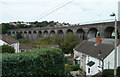
Former railway viaduct, Maesycwmmer
Viewed from Main Road, Maesycwmmer looking past houses on Thomas Street.
The viaduct, now part of National Cycle Network route 47, formerly carried a railway line. 15 of its 16 arches are in view. http://www.geograph.org.uk/photo/1679645 to a view from a nearby position, and a potted history.
Image: © Jaggery
Taken: 27 Aug 2010
0.03 miles
2

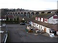
Looking down from the viaduct
The Maesycwmmer - Hengoed Viaduct crosses the River Rhymney at a height of 120 feet.
The roofs in the foreground are of buildings which are a Grade II listed Woollen Mill. Built in 1750, it was originally a corn mill which was later converted to wool manufacturing.
Image: © Robin Drayton
Taken: 23 Jan 2010
0.04 miles
3
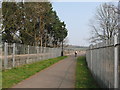
NCN Route 47 near Hengoed viaduct
The former platforms of Heath High Level station are behind the fences on either side.
Image: © Gareth James
Taken: 27 Mar 2011
0.04 miles
4
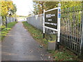
Hengoed 'High Level' railway station (site), Gwent
Opened in 1858 on the Taff Vale Extension Railway to Pontypool, this station closed in 1964. View east onto Maesycwmmer (or Hengoed) Viaduct. The route is now a cycle path.
Image: © Nigel Thompson
Taken: 10 Nov 2012
0.04 miles
7
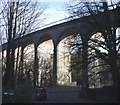
Maesycwmmer - Hengoed Viaduct
The viaduct was built in the 1850s to carry the Taff Vale Extension of the Newport, Abergavenny and Hereford Railway over the Rhymney valley.
It closed to railway traffic in 1964.
It has 16 arches, is 284 yards long and 120 feet high.
In 2000 it was opened for public access and is now part of National Cycle Route 47, the Celtic Way Cycle Route and the Rhymney Valley Ridgeway Walk.
In the foreground, the Butchers Arms is obviously undergoing renovation.
Image: © Robin Drayton
Taken: 23 Jan 2010
0.05 miles
8
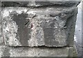
Ordnance Survey Cut Mark
This damaged OS cut mark can be found on the Viaduct between the two lanes of the road.. It marks a point 121.661m above mean sea level.
Image: © Adrian Dust
Taken: 8 Jun 2019
0.05 miles
9
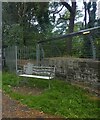
Seat with cut-out figure, Hengoed Viaduct
Image: © David Smith
Taken: 27 Sep 2021
0.05 miles
10
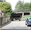
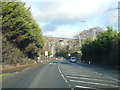
King's Hill railway bridge, Hengoed
On its climb towards Hengoed railway station from New Road (A469), King's Hill passes under a railway bridge with a headroom of 9 feet 3 inches (2.8 metres).
Image: © Jaggery
Taken: 27 Aug 2010
0.05 miles