IMAGES TAKEN NEAR TO
Bridge Street, BARGOED, CF81 9AA
Introduction
This page details the photographs taken nearby to Bridge Street, CF81 9AA by members of the Geograph project.
The Geograph project started in 2005 with the aim of publishing, organising and preserving representative images for every square kilometre of Great Britain, Ireland and the Isle of Man.

There are currently over 7.5m images from over14,400 individuals and you can help contribute to the project by visiting https://www.geograph.org.uk
Image Map
Images are licensed for reuse under creativecommons.org/licenses/by-sa/2.0
Notes
- Clicking on the map will re-center to the selected point.
- The higher the marker number, the further away the image location is from the centre of the postcode.
Image Listing (259 Images Found)
Images are licensed for reuse under creativecommons.org/licenses/by-sa/2.0
Image
Details
Distance
1
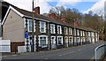
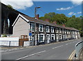
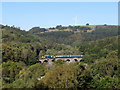
Bridge Street, Bargoed
Bargoed Viaduct is just visible behind this row of houses.
This is the road that crosses the Rhymney Valley and until recent years was the only connection between Bargoed and Aberbargoed.
Image: © Robin Drayton
Taken: 13 Mar 2013
0.00 miles
2
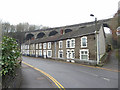
Bridge Street houses and viaduct in Bargoed
Image: © Gareth James
Taken: 1 Mar 2019
0.01 miles
3
Eastern boundary of Bargoed
After a very steep descent from Aberbargoed, Bedwellty Road reaches Bargoed. The boundary sign is on the east bank of the River Rhymney. Behind the houses in Bridge Street is Bargoed Viaduct. http://www.geograph.org.uk/photo/3493002
Image: © Jaggery
Taken: 1 Jun 2013
0.01 miles
4
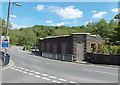
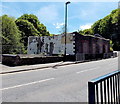
Remains of the fire-damaged Old Mill Hotel, Bargoed (1)
Located opposite Bargoed Viaduct. http://www.geograph.org.uk/photo/3493002
In early January 2012, the Old Mill Hotel bar & restaurant, which had closed down about 18 months earlier, was severely damaged by fire. Seen here are the single-storey remains of the 2-storey building.
http://www.geograph.org.uk/photo/3493131 to a view of the opposite side.
Image: © Jaggery
Taken: 1 Jun 2013
0.01 miles
5
Bridge Street houses Bargoed
Bridge Street is a short (c 50 metres) street between Station Road behind the camera and Bedwellty Road ahead. Bargoed Viaduct http://www.geograph.org.uk/photo/3493002 is on the left.
Image: © Jaggery
Taken: 1 Jun 2013
0.01 miles
6
Remains of the fire-damaged Old Mill Hotel, Bargoed (2)
This is the north side of the former Old Mill Hotel bar & restaurant in Bridge Street near Bargoed Viaduct. http://www.geograph.org.uk/photo/3493002 In early January 2012, the premises, which had closed down about 18 months earlier, were severely damaged by fire. Seen here are the single-storey remains of the former 2-storey building. http://www.geograph.org.uk/photo/3493117 to a view of the south side.
Image: © Jaggery
Taken: 1 Jun 2013
0.02 miles
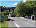
7
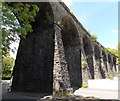
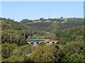
Along Bargoed Viaduct
Viewed from Factory Road. The viaduct carries the Rhymney Line about 250 metres NW of Bargoed railway station. The next station ahead is Brithdir. The viaduct was Grade II listed in 2002 as a visually imposing and fine example of 19th century civil engineering.
Image: © Jaggery
Taken: 1 Jun 2013
0.02 miles
8
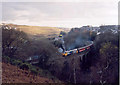
Bargoed Viaduct
Class 50, number 50031 Hood heads north over Bargoed viaduct, with a special service to mark the end of loco-hauled trains on the Rhymney line.
Image: © Gareth James
Taken: 4 Dec 2005
0.02 miles
9
Class 37 on Bargoed Viaduct
Class 37 No. 37421 crosses Bargoed viaduct with a Cardiff Canton depot to Rhymney training run.
Image: © Gareth James
Taken: 20 Sep 2019
0.02 miles
10
Class 37 on Bargoed Viaduct
Class 37 No. 37025 crosses Bargoed viaduct on the rear of a Cardiff Canton depot to Rhymney training run.
Image: © Gareth James
Taken: 20 Sep 2019
0.02 miles