1
A waste of paint - Cowbridge
So the road was so narrow that they wanted to keep vehicles on the safe side of the road!
Image: © Mick Lobb
Taken: 11 Dec 2009
0.09 miles
2
A footpath, narrow and dark
Image: © Alan Hughes
Taken: 22 Aug 2024
0.13 miles
3
Invaders near Cowbridge
In what might be considered an idyllic landscape rapidly growing invaders of the hedgerows have sprung into life.
I believe this to be Himalayan Balsam (Impatiens glandulifera), an introduced horticultural specimen, related to the Busy Lizzie, that came to Britain in 1839 and has since escaped to become a major nuisance in the wild.
It is the tallest annual in the UK growing up to 3 metres tall in a season before dying back in autumn. An attractive plant with a distinctive purple pink flower that belies its destructive nature. Its flower has led to its slang name of 'Policeman's Helmet'- not that I have seen any poicemen wearing pink helmets as yet!
Each plant can produce up to 800 seeds and these are explosively released when their pods are mature. The 'explosion' can project the seeds up to 7 metres from the parent plant. This highly effective dispersal method enables the plant to rapidly colonise the damp and riparian habitats that it usually favours. The seeds may be further spread by water, explaining its favoured environment, and can remain viable for 2 years
Image: © Mick Lobb
Taken: 20 Apr 2009
0.15 miles
4
Edmondes Arms, Jack's Corner, Cowbridge
Pub on the corner of Cardiff Road and Aberthin Road. Both roads are the A4222 which makes a 90 degree turn here.
The name Jack’s Corner on the building recalls a dog that once lived here. The year on the pub name sign is 1899, but there is a reference to The Edmondes Arms Public House in an 1895 edition of a Kelly's Directory, so presumably the current building was built on the site of its predecessor. The Directory records that a Mrs Edmondes of High Street is a "principal landowner" in Cowbridge.
Image: © Jaggery
Taken: 19 Jan 2012
0.16 miles
5
Trio Brasserie, Cowbridge
Located in eastern Cowbridge at the crossroads of Cardiff Road, Aberthin Road, Eastgate and St Athan Road. The Shorter Oxford English Dictionary defines brasserie as
"A (French) saloon selling beer and usually food; generally, an informal restaurant."
The second definition applies here.
Image: © Jaggery
Taken: 19 Jan 2012
0.16 miles
6
Bench Mark, Cowbridge
This bench mark is in the bus shelter against the remaining bridge parapet of the long closed Cowbridge and Aberthaw railway.
It is shown on the 1909 OS map but appears to be from George V or VI's era. Perhaps it is a replacement for an earlier one. The recorded elevation on the map is 101.3ft
Image: © Guy Butler-Madden
Taken: 23 Feb 2012
0.16 miles
7
Ordnance Survey Cut Mark
This OS cut mark can be found on the north parapet of the old railway bridge on Cardiff Road. It marks a point 41.087m above mean sea level.
Image: © Adrian Dust
Taken: 19 Apr 2018
0.16 miles
8
End of 30mph speed limit at the eastern edge of Cowbridge
The speed limit along the A4222 increases from 30mph to the National Speed Limit on crossing the eastern boundary http://www.geograph.org.uk/photo/2770778 of Cowbridge.
Image: © Jaggery
Taken: 19 Jan 2012
0.17 miles
9
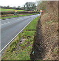
Ditch at the northern edge of the A4222 near Cowbridge
The Cowbridge boundary sign http://www.geograph.org.uk/photo/2770778 is ahead on the left.
Image: © Jaggery
Taken: 19 Jan 2012
0.17 miles
10
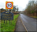
Eastern boundary of Cowbridge, Vale of Glamorgan
The A4222 from the east enters the ancient borough of Cowbridge. The Welsh name for the town is Y Bont-faen, literally The Stone Bridge. The sign shows that Cowbridge is twinned with Clisson, France.
Image: © Jaggery
Taken: 19 Jan 2012
0.17 miles


