IMAGES TAKEN NEAR TO
Bonvilston, CARDIFF, CF5 6TN
Introduction
This page details the photographs taken nearby to CF5 6TN by members of the Geograph project.
The Geograph project started in 2005 with the aim of publishing, organising and preserving representative images for every square kilometre of Great Britain, Ireland and the Isle of Man.

There are currently over 7.5m images from over14,400 individuals and you can help contribute to the project by visiting https://www.geograph.org.uk
Image Map
Images are licensed for reuse under creativecommons.org/licenses/by-sa/2.0
Notes
- Clicking on the map will re-center to the selected point.
- The higher the marker number, the further away the image location is from the centre of the postcode.
Image Listing (21 Images Found)
Images are licensed for reuse under creativecommons.org/licenses/by-sa/2.0
Image
Details
Distance
1
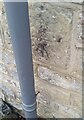
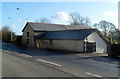
Ordnance Survey Cut Mark
This OS cut mark can be found on the barn conversion at Sheep Court Farm. It marks a point 96.299m above mean sea level.
Image: © Adrian Dust
Taken: 30 Oct 2021
0.04 miles
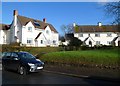
2
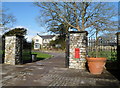
Court Farm, Bonvilston
House on the north side on the A48 in the Vale of Glamorgan village of Bonvilston.
Image: © Jaggery
Taken: 27 Jan 2012
0.06 miles
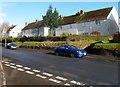
3
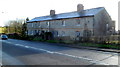
Sheep Court Cottages, Bonvilston
The row of four cottages on the south side of the A48 was built in the late 19th century.
The cottage furthest from the camera is Shepherds Lodge, a B&B (bed and breakfast accommodation).
Image: © Jaggery
Taken: 27 Jan 2012
0.07 miles
4
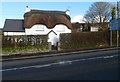
Sheepcourt Cottage, Bonvilston
The thatched, whitewashed cottage is on the north side of the A48, at the eastern edge of the Vale of Glamorgan village of Bonvilston.
Image: © Jaggery
Taken: 27 Jan 2012
0.08 miles
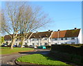
5
Maes-y-ffynon houses, Bonvilston
Located on the north side of the A48, Maes-y-ffynon is a residential street leading to houses in Cottrell Drive and Village Farm.
Image: © Jaggery
Taken: 27 Jan 2012
0.12 miles
6
Maes-y-ffynon semis, Bonvilston
Houses in the middle section of Maes-y-ffynon, viewed from the turning into the residential cul-de-sac Village Farm.
Image: © Jaggery
Taken: 27 Jan 2012
0.12 miles
7
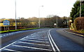
Eastern boundary of Bonvilston
The A48, between Cardiff and Cowbridge, reaches the boundary sign at the eastern edge of the village of Bonvilston, Vale of Glamorgan. The village is named after Simon de Bonville, a Norman nobleman.
The Welsh name of the village shown on the sign is Dresimwn (Simon's town).
Image: © Jaggery
Taken: 27 Jan 2012
0.13 miles
8
Northern end of Maes-y-ffynon, Bonvilston
These houses are near the SW edge of a golf course.
Image: © Jaggery
Taken: 27 Jan 2012
0.15 miles
9
The Old Barn, Bonvilston
Located on the south side of the A48, the former farm building has been converted for business and residential use.
Image: © Jaggery
Taken: 27 Jan 2012
0.19 miles
10
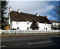
Grade II listed former Village Farm farmhouse, Bonvilston
The thatched cottage on the north side of the A48 dates from the early 18th century, with 19th century alterations. Grade II listed in July 1995.
Image: © Jaggery
Taken: 27 Jan 2012
0.19 miles