1
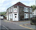
Flats in former Bethesda Chapel, Trehafod
The former chapel, built in the 1880s on the corner of Trehafod Road and Bethesda Street, has been converted to flats.
Image: © Jaggery
Taken: 6 May 2011
0.02 miles
2
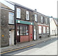
Ty Gwyn guest house, Trehafod
Guest house offering bed & breakfast accommodation, located on the corner of Trehafod Road and Cross Street. The guest house is open all year.
Image: © Jaggery
Taken: 6 May 2011
0.02 miles
3
Former Post Office, Trehafod
Image: © David Pike
Taken: Unknown
0.03 miles
4
Trehafod Road
Image: © Colin Pyle
Taken: 4 Jan 2010
0.04 miles
5
Flood defence wall (1), Trehafod
There were damaging floods from the River Rhondda in Trehafod on several occasions in the twentieth century. The most serious and widespread flood was in 1960, when one man died.
In the late 1990s, a flood defence wall was built along the north bank of the Rhondda in Trehafod. This section is to the east of the junction of Bethesda Street and Lewis Street.
http://www.geograph.org.uk/photo/2397505 to a view of the wall in the opposite direction.
Image: © Jaggery
Taken: 6 May 2011
0.05 miles
6
Former Trehafod post office
Located at 110 Trehafod Road. The disappearance of the name of the post office, which had begun in this view http://www.geograph.org.uk/photo/1217341 is now complete.
A Post Office notice on a window states:
"Following a local public consultation process we have recently announced the decision to close this branch as part of a national Network Change Programme. We can confirm that this branch will close on the following date:
Friday 29th February 2008
We do hope that you continue to use the alternative branches in your area, please see the decision poster for full details on the locations and services."
The Edward VII postbox http://www.geograph.org.uk/photo/2397422 in the wall is in very good condition and looks like it was recently repainted.
Image: © Jaggery
Taken: 6 May 2011
0.06 miles
7
Edward VII postbox, Trehafod
The recently-painted postbox is in the wall of the former Trehafod post office http://www.geograph.org.uk/photo/2397418 which closed at the end of February 2008.
Image: © Jaggery
Taken: 6 May 2011
0.06 miles
8
Former Trehafod Memorial Hall & Institute
Despite its Grade II listing, this once grand building on Trehafod Road is now an eyesore, with a pile of junk visible behind the railings, and a general appearance of decay.
Image: © Jaggery
Taken: 6 May 2011
0.06 miles
9
Morgannwg Street, Trehafod
Houses on the north side of Morgannwg Street, which runs almost exactly east to west. The far end of the street connects with Cross Street.
Image: © Jaggery
Taken: 6 May 2011
0.06 miles
10
Trehafod Memorial Hall and Institute
Trehafod Community Hall - note the deterioration when you compare
Image taken two years ago.
Image: © Alan Hughes
Taken: 9 Mar 2017
0.06 miles


