IMAGES TAKEN NEAR TO
Station Row, BRIDGEND, CF32 8PJ
Introduction
This page details the photographs taken nearby to Station Row, CF32 8PJ by members of the Geograph project.
The Geograph project started in 2005 with the aim of publishing, organising and preserving representative images for every square kilometre of Great Britain, Ireland and the Isle of Man.

There are currently over 7.5m images from over14,400 individuals and you can help contribute to the project by visiting https://www.geograph.org.uk
Image Map
Images are licensed for reuse under creativecommons.org/licenses/by-sa/2.0
Notes
- Clicking on the map will re-center to the selected point.
- The higher the marker number, the further away the image location is from the centre of the postcode.
Image Listing (25 Images Found)
Images are licensed for reuse under creativecommons.org/licenses/by-sa/2.0
Image
Details
Distance
1
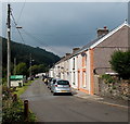
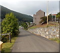
Station Row houses, Pontyrhyl
Located below the A4064 in Lluest. The houses are near the site of Pontyrhyl railway station,
where passenger services ended in 1953. The railway track along the Garw Valley is still in place between Brynmenyn and Pontycymer.
Image: © Jaggery
Taken: 6 Sep 2014
0.02 miles
2
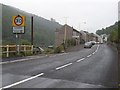
Named bus shelter in Lluest
The name of the hamlet is inscribed on the bus shelter alongside the A4064.
Image: © Jaggery
Taken: 6 Sep 2014
0.03 miles
3
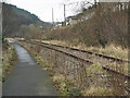
Disused railway and cycle path in the Garw Valley
Seen at Pont-y-rhyl, a section of the Garw Valley Railway and, alongside it, a stretch of the Garw Valley Community Route, a path for cyclists and walkers which is classed as Route 884 of the National Cycle Network. The path runs up the valley beside the railway as far as Pontycymer, where the railway ends. It then continues northwards to Blaengarw at the head of the valley.
Image: © eswales
Taken: Unknown
0.03 miles
4
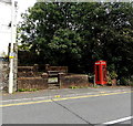
Red phonebox and benches in Lluest
Viewed across the A4064. The benches are in a neglected-looking bricked-off area.
Image: © Jaggery
Taken: 6 Sep 2014
0.03 miles
5
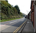
Main road through Lluest
The A4064 is the main road above the Garw Valley, from Blaengarw
in the north to the A4065 junction in Abergarw north of Bridgend.
Image: © Jaggery
Taken: 6 Sep 2014
0.04 miles
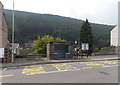
7
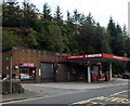
Pontyrhyl Service Station in Lluest
The premises of W. Braund & Son alongside the A4064
include a Murco filling station, shop and MoT test centre.
Image: © Jaggery
Taken: 6 Sep 2014
0.05 miles
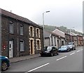
8
Station Row, Lluest
Viewed from the corner of the A4064, the main road through Lluest.
This used to be the way to Pontyrhyl railway station, where passenger services ended in 1953.
The railway track along the Garw Valley is still in place between Brynmenyn and Pontycymer.
Image: © Jaggery
Taken: 6 Sep 2014
0.05 miles
9
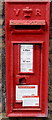
Victorian postbox in Lluest
In a house wall here. http://www.geograph.org.uk/photo/4159110
Notices stuck on the box give details of changes
to last collection time from here each day.
Image: © Jaggery
Taken: 6 Sep 2014
0.06 miles
10
Postbox in a house wall, Lluest
Viewed across the A4064. The red postbox on the left is Victorian. http://www.geograph.org.uk/photo/4159105
Image: © Jaggery
Taken: 6 Sep 2014
0.07 miles