IMAGES TAKEN NEAR TO
Maes Y Piod, BRIDGEND, CF31 5FJ
Introduction
This page details the photographs taken nearby to Maes Y Piod, CF31 5FJ by members of the Geograph project.
The Geograph project started in 2005 with the aim of publishing, organising and preserving representative images for every square kilometre of Great Britain, Ireland and the Isle of Man.

There are currently over 7.5m images from over14,400 individuals and you can help contribute to the project by visiting https://www.geograph.org.uk
Image Map
Images are licensed for reuse under creativecommons.org/licenses/by-sa/2.0
Notes
- Clicking on the map will re-center to the selected point.
- The higher the marker number, the further away the image location is from the centre of the postcode.
Image Listing (7 Images Found)
Images are licensed for reuse under creativecommons.org/licenses/by-sa/2.0
Image
Details
Distance
1
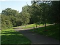
The start of a cycle path in the north west of Broadlands
This cycle path strikes out from a spot on Heol Blandy and runs towards the centre of Broadlands. From there it is possible to continue towards the centre of Bridgend. A junction of the cycle path with a footpath is seen in the image.
Note that this image is of the more northerly of two branches which maps indicate the cycle route at Broadlands divides into to the west of the B4622.
Image: © eswales
Taken: 24 Aug 2021
0.16 miles
2
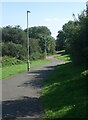
Cycle route, Broadlands
A cycle route meandering along a pleasant green corridor in the west of Broadlands. The path runs to the centre of the Bridgend suburb and, thereafter, towards the centre of the town itself.
Note that this image is of the more northerly of two branches which maps indicate the cycle route at Broadlands divides into to the west of the B4622.
Image: © eswales
Taken: 24 Aug 2021
0.16 miles
3
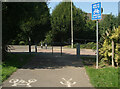
Western end of cycle route, Broadlands
The image shows the end of a cycle path at a spot on Heol Blandy in the north west of Broadlands. This is the end of the more northerly of two branches which maps indicate the cycle route at Broadlands divides into to the west of the B4622.
Note the symbols on the ground which, for the safety and convenience of those about to set off along the path, indicate the separate sides of it which cyclists and pedestrians should use.
Image: © eswales
Taken: 24 Aug 2021
0.17 miles
4
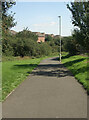
Cycle path and houses at Broadlands
A stream flows between the two, alongside the line of vegetation seen running across the image.
Image: © eswales
Taken: 24 Aug 2021
0.18 miles
5
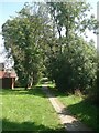
Public footpath in the north west of Broadlands (2)
A stretch of public footpath lying just to the east of the one seen in Image A few of the many mature deciduous trees in this residential area of Bridgend are passed here.
Image: © eswales
Taken: 24 Aug 2021
0.22 miles
6
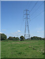
Pylon to the south of Laleston
One of several pylons south of Laleston which lie close to the A48.
Image: © eswales
Taken: 24 Aug 2021
0.22 miles
7
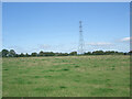
Uncultivated field and pylon to the south of Laleston
A public footpath on the Bridgend Circular Walk passes through the field, which borders the A48. The pylon lies just outside the field.
Image: © eswales
Taken: 24 Aug 2021
0.25 miles