IMAGES TAKEN NEAR TO
Drysgol Road, CARDIFF, CF15 8FS
Introduction
This page details the photographs taken nearby to Drysgol Road, CF15 8FS by members of the Geograph project.
The Geograph project started in 2005 with the aim of publishing, organising and preserving representative images for every square kilometre of Great Britain, Ireland and the Isle of Man.

There are currently over 7.5m images from over14,400 individuals and you can help contribute to the project by visiting https://www.geograph.org.uk
Image Map
Images are licensed for reuse under creativecommons.org/licenses/by-sa/2.0
Notes
- Clicking on the map will re-center to the selected point.
- The higher the marker number, the further away the image location is from the centre of the postcode.
Image Listing (198 Images Found)
Images are licensed for reuse under creativecommons.org/licenses/by-sa/2.0
Image
Details
Distance
1
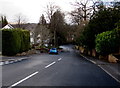
Drysgol Road descends towards the B4262, Radyr, Cardiff
A sign behind the camera shows a 10% (1 in 10) gradient. http://www.geograph.org.uk/photo/4369662
Image: © Jaggery
Taken: 3 Mar 2015
0.02 miles
2
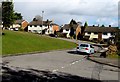
East side of The Green, Radyr, Cardiff
The Green is an area of houses arranged around a grass rectangle with rounded corners, north of Windsor Road.
Image: © Jaggery
Taken: 3 Mar 2015
0.05 miles
3
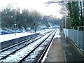
NW edge of Radyr railway station, Cardiff
Viewed from platform 1. The next station is this direction is Taffs Well.
Image: © Jaggery
Taken: 29 Nov 2010
0.05 miles
4
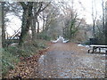
Path on the east bank of the River Taff near Radyr weir
The path heads away from a picnic area near Radyr weir. http://www.geograph.org.uk/photo/2191399
Image: © Jaggery
Taken: 29 Nov 2010
0.05 miles
5
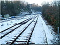
Railway lines NW of Radyr station, Cardiff
The view from the NW edge of platform 1. The next station is this direction is Taffs Well.
Image: © Jaggery
Taken: 29 Nov 2010
0.05 miles
6
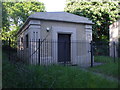
Anonymous building, Heol Isaf, Radyr, Cardiff
Image: © John Lord
Taken: 22 May 2010
0.06 miles
7
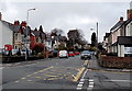
Heol Isaf, Radyr, Cardiff
Looking north from the corner of Station Road.
The red board on the left is at the edge of Radyr Methodist Church. http://www.geograph.org.uk/photo/3915651
Image: © Jaggery
Taken: 4 Apr 2014
0.07 miles
8
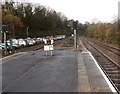
Western end of Radyr railway station
The next station ahead is Taffs Well, nearly 3km away.
Signal identifiers in view are VR622 on the right and VR520 on the left.
Image: © Jaggery
Taken: 19 Feb 2014
0.08 miles
9
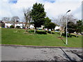
Trees on The Green, Radyr, Cardiff
The Green is an area of houses arranged around a grass rectangle with rounded corners, north of Windsor Road.
Image: © Jaggery
Taken: 3 Mar 2015
0.08 miles
10
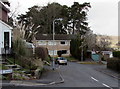
The Uplands, Radyr, Cardiff
Cul-de-sac on the north side of Drysgol Road.
Image: © Jaggery
Taken: 3 Mar 2015
0.08 miles