IMAGES TAKEN NEAR TO
Huntingdon Road, CAMBRIDGE, CB3 0JX
Introduction
This page details the photographs taken nearby to Huntingdon Road, CB3 0JX by members of the Geograph project.
The Geograph project started in 2005 with the aim of publishing, organising and preserving representative images for every square kilometre of Great Britain, Ireland and the Isle of Man.

There are currently over 7.5m images from over14,400 individuals and you can help contribute to the project by visiting https://www.geograph.org.uk
Image Map
Images are licensed for reuse under creativecommons.org/licenses/by-sa/2.0
Notes
- Clicking on the map will re-center to the selected point.
- The higher the marker number, the further away the image location is from the centre of the postcode.
Image Listing (49 Images Found)
Images are licensed for reuse under creativecommons.org/licenses/by-sa/2.0
Image
Details
Distance
1
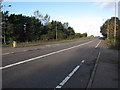
Huntingdon Road
Close to the A14/M11 junction.
Image: © Hugh Venables
Taken: 13 Oct 2012
0.03 miles
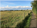
3
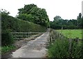
Path from Coton to Girton
The stretch of the path immediately south of Huntingdon Road, near Howe's Farm and Girton College.
Image: © John Sutton
Taken: 5 Jul 2012
0.06 miles
4
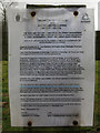
Cambridge University Farm planning notice
Giving details of the planning permission sought. The development proposed includes: 3000 dwellings; up to 2000 student bedspaces; 100,000 sq. m. employment floorspace, of which: up to 40,000 sq. m. commercial floorspace and at least 60,000 sq. m. academic floorspace; up to 5,300 sq. m. gross retail floospace; Senior Living [not including professors' offices], up to 6,500 sq. m.; community centre; indoor sports provision; police; primary health care; primary school; nurseries; hotel (130 rooms); energy centre and associated road, cycle, pedestrian, parking and drainage infrastructure. And some open space. It's a big submission with the cost estimated at about £1 billion and construction of phase one, which has just started, taking over two years.
Image: © Hugh Venables
Taken: 9 Mar 2013
0.06 miles

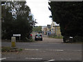
6
Looking towards Howe's Farm
This will soon be one of the access points into the north-west Cambridge development, which is converting the University Farm into a mix of residential and academic uses. It will also help link Huntingdon and Madingley Road and provide additional services to the west of Cambridge.
Image: © Hugh Venables
Taken: 9 Mar 2013
0.10 miles
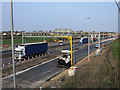
9
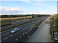
A14 widening
Looking over the old slip road for the M11.
Image: © Hugh Venables
Taken: 23 Aug 2014
0.11 miles
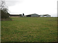
10
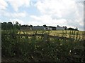
Howe's Farm
The farm is opposite Girton College (behind the trees on the left skyline). The picture was taken from the Girton-Coton footpath on a cloudy July afternoon.
Image: © John Sutton
Taken: 5 Jul 2012
0.12 miles