IMAGES TAKEN NEAR TO
Linton Road, CAMBRIDGE, CB21 6BS
Introduction
This page details the photographs taken nearby to Linton Road, CB21 6BS by members of the Geograph project.
The Geograph project started in 2005 with the aim of publishing, organising and preserving representative images for every square kilometre of Great Britain, Ireland and the Isle of Man.

There are currently over 7.5m images from over14,400 individuals and you can help contribute to the project by visiting https://www.geograph.org.uk
Image Map (Loading...)


Getting Data...Please wait
Leaflet Map data © OpenStreetMap
Images are licensed for reuse under creativecommons.org/licenses/by-sa/2.0
Notes
- Clicking on the map will re-center to the selected point.
- The higher the marker number, the further away the image location is from the centre of the postcode.
Image Listing (17 Images Found)
Images are licensed for reuse under creativecommons.org/licenses/by-sa/2.0
Image
Details
Distance
1
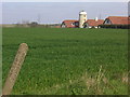
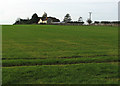
Disused Mill
Disused mill near Hildersham, viewed from A1307
Image: © Oda Stoevesandt and Karsten Koehler
Taken: 6 Apr 2007
0.01 miles
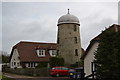
3
Houses at Hildersham Windmill
A view across a rolled field from the side of the A1307, taken on a bright early-autumn morning. For a spring view, see Image
Image: © John Sutton
Taken: 1 Oct 2015
0.03 miles
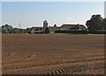
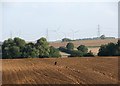
4
Hildersham to Rivey Hill
A view east, against the light on a bright October morning, from near the junction with the A1307 south of the village. The old windmill is two fields away, Linton Water Tower and Rivey Wood on the skyline a mile and a half away.
Image: © John Sutton
Taken: 17 Oct 2013
0.03 miles
5
Hildersham: up hill to the windmill
A view from the footpath from Hildersham to Linton. The windmill is Grade II listed: http://www.britishlistedbuildings.co.uk/en-51870-four-winds-oakley-soils-limited-hildersha#.VoJTLSiT7ZY .
Image: © John Sutton
Taken: 28 Dec 2015
0.05 miles
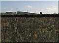
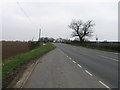
6
Near Hildersham: north-east from the A1307
A foreshortened view over fields and across the valley of the River Granta, with some of the turbines of Wadlow Wind Farm - about three miles away - on the skyline
Image: © John Sutton
Taken: 1 Oct 2015
0.11 miles
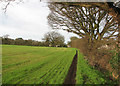
8
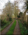
Track to Hildersham Mill
Shared by a public footpath.
Image: © John Sutton
Taken: 28 Dec 2015
0.13 miles
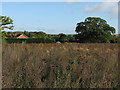
9
Hildersham: field-edge footpath
Near the Hildersham end of the footpath from Linton.
Image: © John Sutton
Taken: 28 Dec 2015
0.14 miles
10
Hildersham to Wadlow
A view across Hildersham (hidden in the valley) from near the main road, with some of the turbines of Wadlow Wind Farm on the skyline.
Image: © John Sutton
Taken: 17 Oct 2013
0.16 miles